

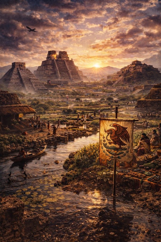
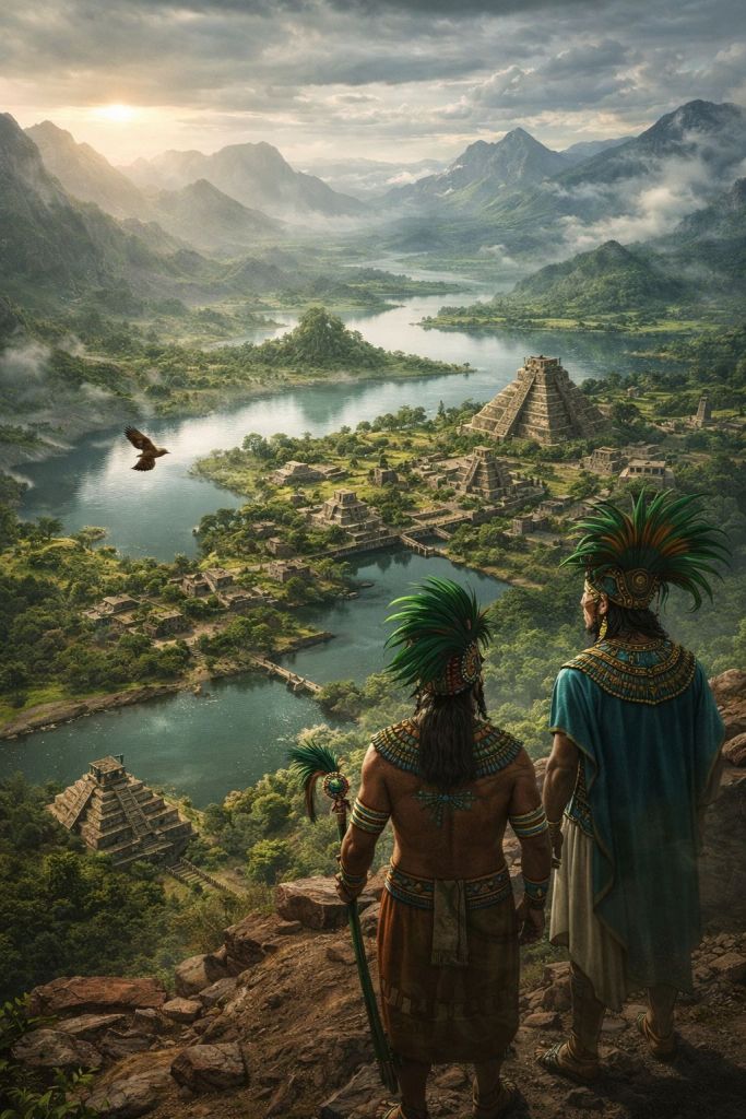
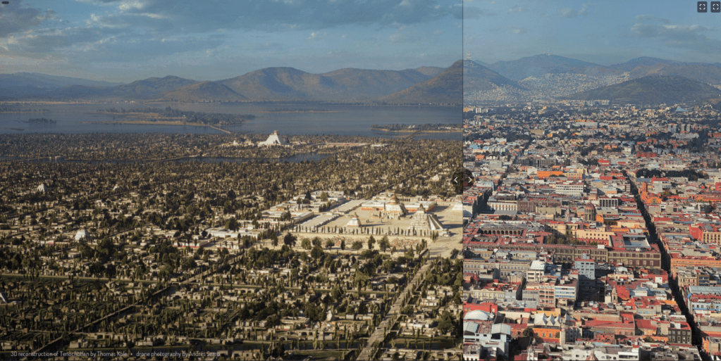
This city would have possessed a beauty like no other.
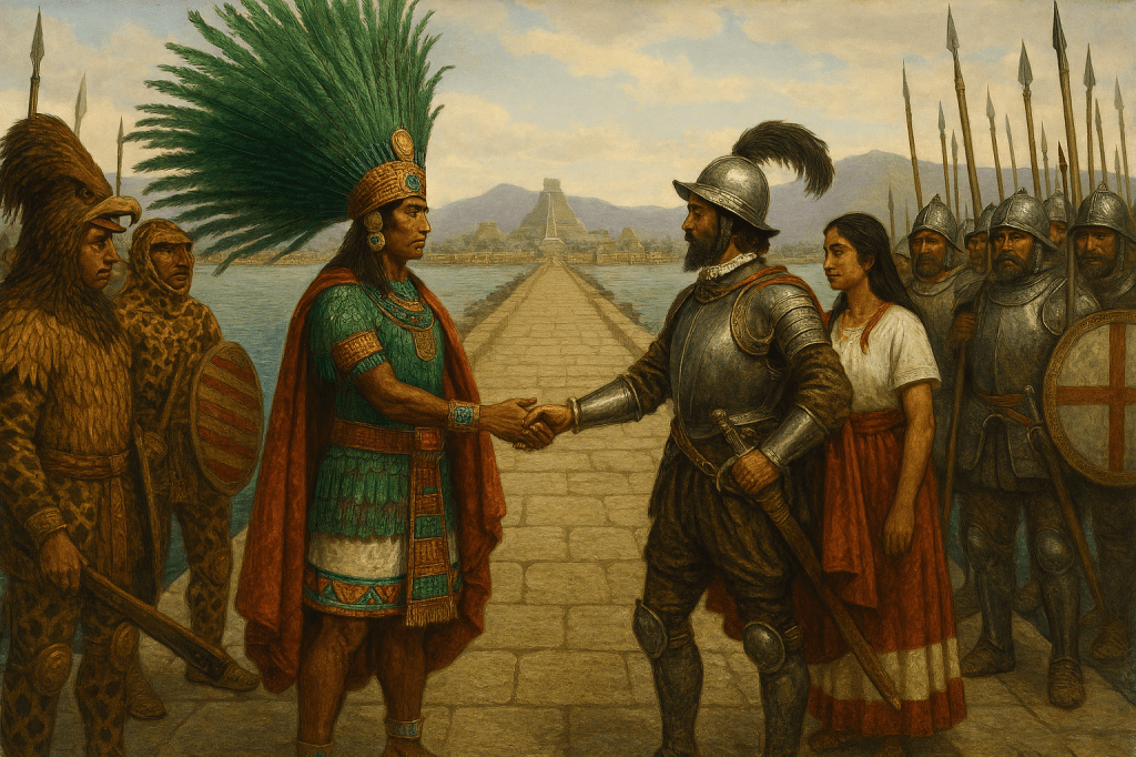
I am not at all surprised that some conquistadors felt as though they were experiencing a fantastical dream. When Hernán Cortés arrived in 1519, he was awestruck. In letters to the Spanish king, he compared Tenochtitlan favorably to Venice and declared it more beautiful than any city in Spain. His soldiers wandered the markets and causeways in amazement, struggling to comprehend how such a civilization had been built.
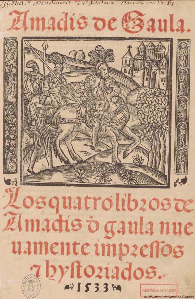
Conquistador Bernal Díaz del Castillo (1) wrote…..
- Bernal Díaz del Castillo (1495 – 1584) was a Spanish soldier and author, who took part in the conquest of Mexico. Written around 1568 and published posthumously in 1632, after the original manuscript was found, was his book “Historia verdadera de la conquista de la Nueva España” (True History of the Conquest of New Spain : Eng. trans. The True History of the Conquest of Mexico). The book offered a first-hand account of the conquest of Mexico (1519-1521) from the perspective of a foot soldier and describes 119 battles, including the march to Tenochtitlan, the entry into the city, the fall of the Aztec Empire, and details of daily life and the geography of the new territory. He wrote the book (partly) to refute the works of other authors, most notably Francisco López de Gómara, who romanticised and overstated Cortés’s role. Francisco López de Gómara (February 2, 1511 – c. 1564) was a Spanish historian who worked in Seville and is particularly noted for his works in which he described the early 16th century expedition undertaken by Hernán Cortés in the Spanish conquest of the New World. Although he had first-hand access to Cortés and others of the returning conquistadores as the sources of his account Gómara himself did not accompany Cortés, and had in fact never been to the Americas. In response del Castillo recounted his personal experiences of the conquest and praised the 700 soldiers that formed the expedition, declaring that they had endured much suffering and hardship in acquiring Mexico for Spain, and that they had not received due recognition for their actions. Diaz’s account is written in an unassuming, colloquial style and has both historical and artistic value. It is also a sourcebook of idiomatic 16th-century Spanish.
“During the morning, we arrived at a broad Causeway (1) and continued our march towards Iztapalapa, and when we saw so many cities and villages built in the water and other great towns on dry land and that straight and level Causeway going towards Mexico, we were amazed and said that it was like the enchantments they tell of in the legend of Amadis (2), on account of the great towers and cues (3) and buildings rising from the water, and all built of masonry. And some of our soldiers even asked whether the things that we saw were not a dream. It is not to be wondered at that I here write it down in this manner, for there is so much to think over that I do not know how to describe it, seeing things as we did that had never been heard of or seen before, not even dreamed about.”
- The Causeway of Cuitlahuac separating the lake of Chalco from the lake of Xochimilco.The term “Causeway of Cuitlahuac” usually refers to the Tlacopan (Tacuba) Causeway that ran west from Tenochtitlan, famously used by Hernán Cortés during his disastrous retreat known as La Noche Triste (The Night of Sorrows) in 1520.
- Amadís de Gaula is a foundational 14th-century Spanish chivalric romance—popularized in a 1508 edition by Garci Rodríguez de Montalvo—following the adventures of Amadís, the, “perfect knight”. Born in secret to King Perión and Elisena, he is abandoned, raised in Scotland, and faces giants, enchanters, and tests of love to prove his worth.
- temples
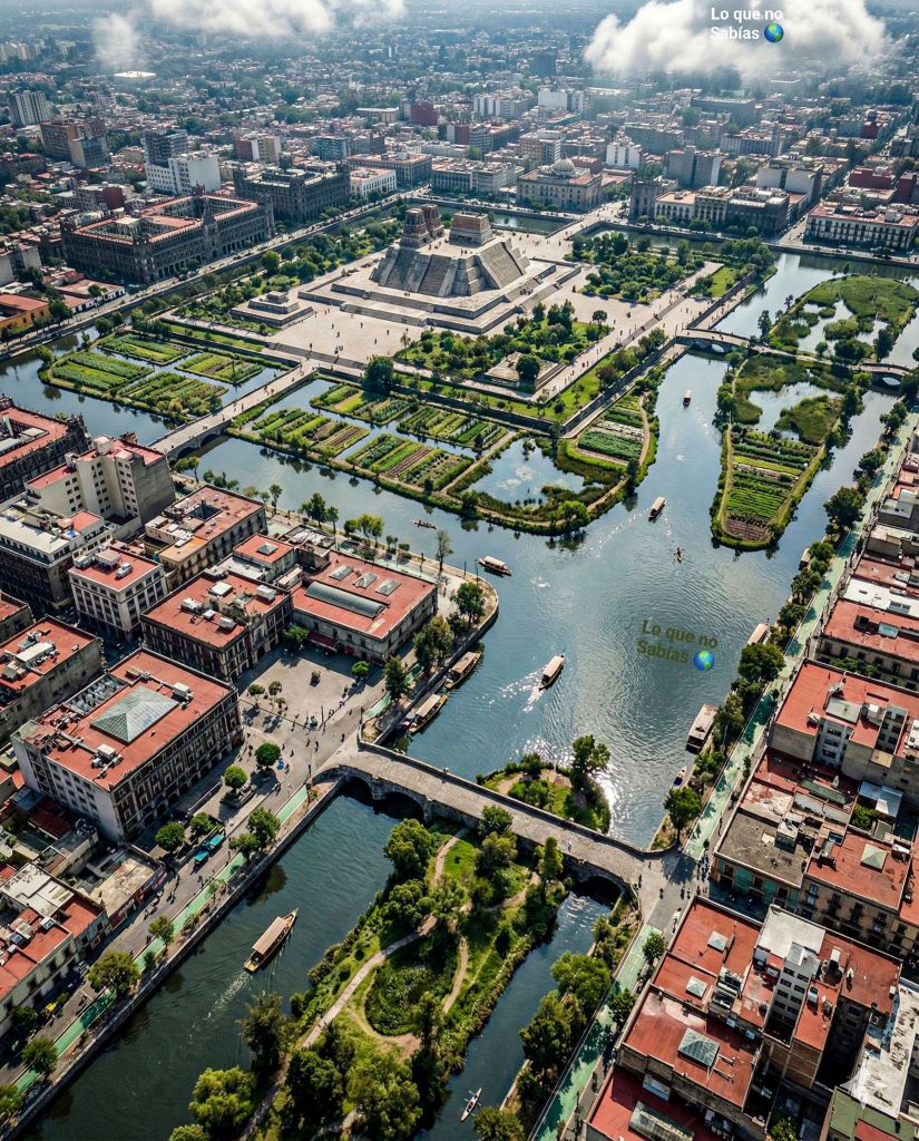
Sunrise over the Templo Mayor
Lo que no sabias, a Facebook Community, invites you to share with them “The forbidden history and secrets of Ancient Mexico. Mexicas, Mayas, etc., and gods like you’ve never seen them before”
A number of images in this Post are to be found on Dioses Ocultos on Facebook. Like Lo que no sabias they offer insight into the historia mexica and invite you to “explore myths and legends from ancient civilizations. Discover the symbolism, history, and messages that remain alive in human culture” and to take “A journey through mythology and ancestral thought”.
I’m pretty sure both of these sites are A.I. generated. They do offer imagery I have yet to see elsewhere.
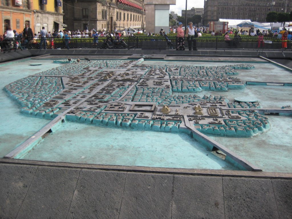
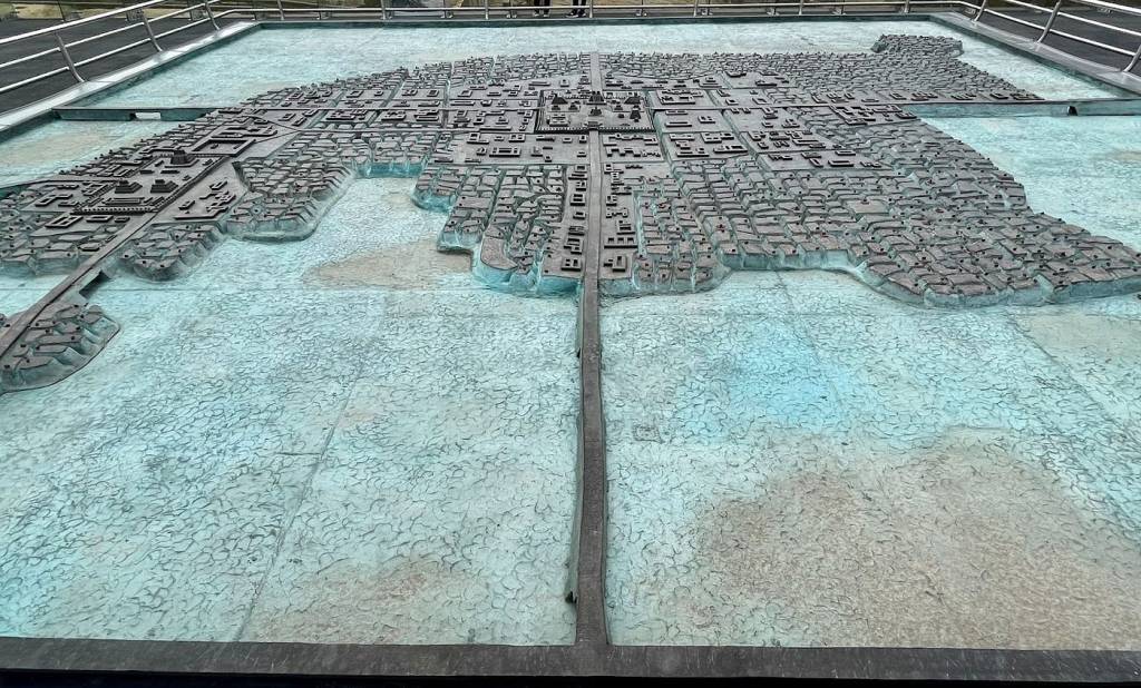
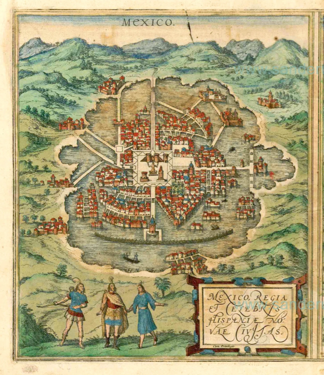
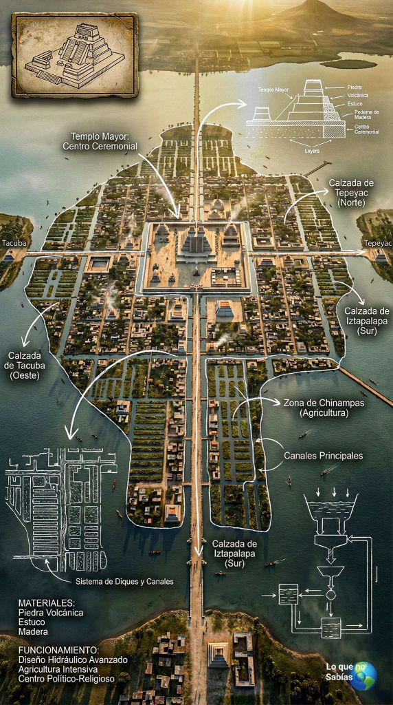
Map of Tenochtitlan at the Templo Mayor in Mexico City
Please take in mind that many of the A.I. generated images as seen on Lo que no sabias and Dioses Ocultos suffer from “artistic licence” as generated by the logic of artificial intelligence so you’ll find them somewhat inaccurate. For example, some images of Tenochtitlan contain pyramids from other regions i.e. El Castillo from Chichen Itza pops up in a few images. This is a Mayan pyramid from the Yucatan, an area far removed from the Basin of Mexico.
A.I. cannot be blamed for its inaccuracies. Many images of Tenochtitlan as drawn by those who (presumably) witnessed it first hand contain many inaccuracies but these were a result of cultural biases.
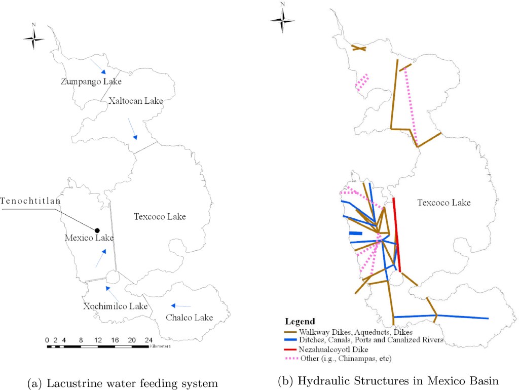
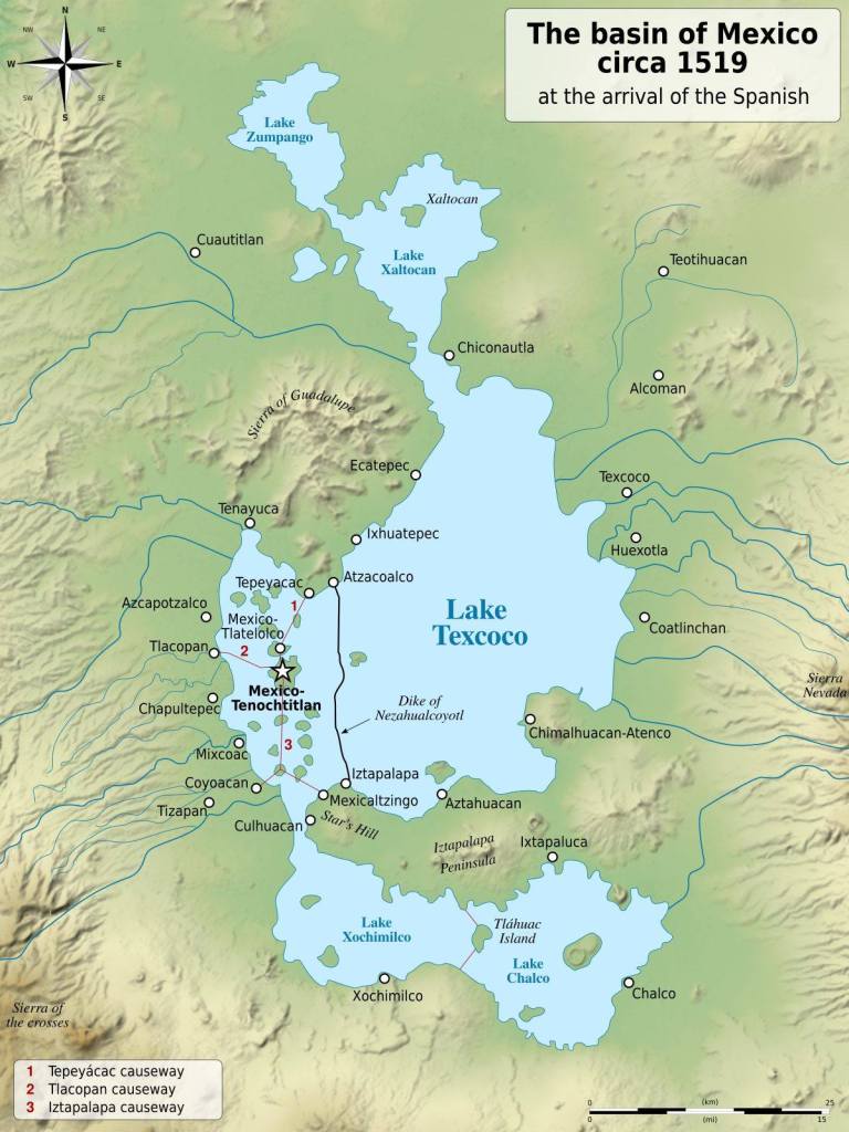
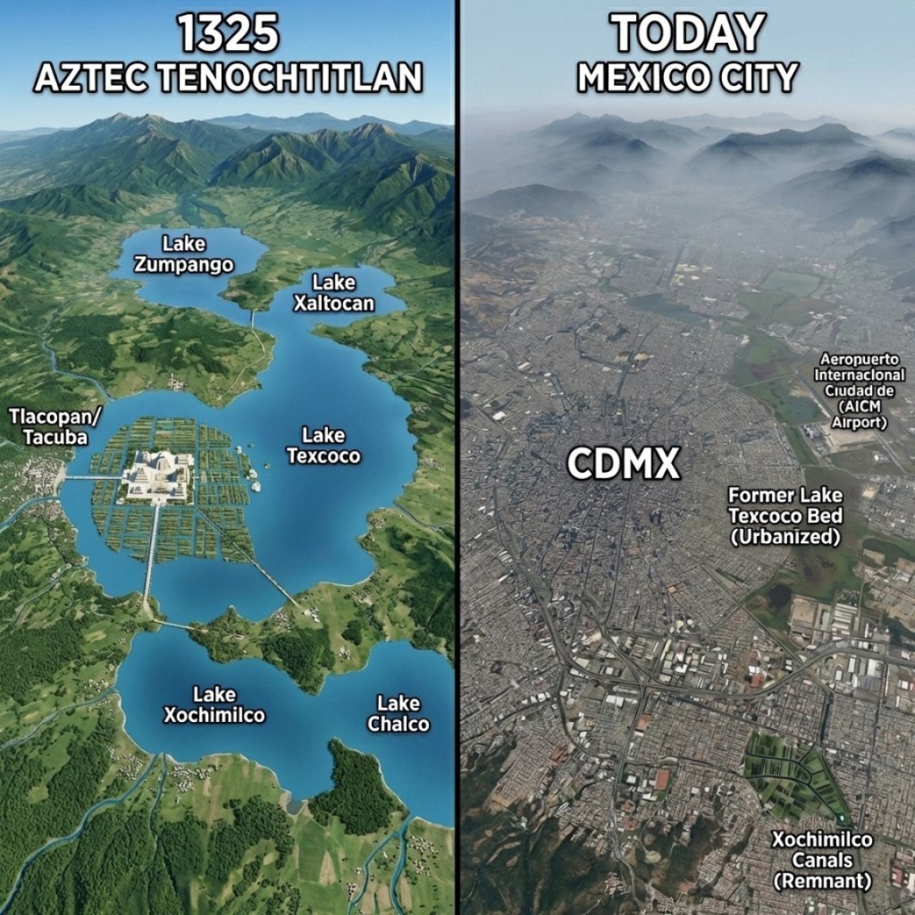
The basin that comprised the Valley of Mexico contained five endoheric (1) lakes: Zumpango, Xaltocan, Texcoco, Xochimilco, and Chalco and around the year 1519 (the peak of the Aztec empire) the lakes, lagoons, and swamps of the basin covered around 1000 km2 of the total surface of the Valley of Mexico.
- the lakes had no outlet, were hydraulically connected, and formed one enormous lake when flooded.
The lakes were shallow, with a depth of no more than 150 ft (45 m) and water quality between them varied markedly. The more isolated southern lakes of Xochimilco and Chalco were higher and protected by the high peninsula formed by Cerro de la Estrella on the east and a “lava plug” to the west; these lakes were fed by springs and rivers, and so held fresh water.
Drainage from the higher lakes flowed north to Texcoco (the largest lake), Zumpango, and Xaltocan; the waters of these lakes were brackish (1).
- Brackish water is a mixture of fresh water and salt water, containing higher salinity than fresh water (0.5 parts per thousand) but less than ocean water (35 parts per thousand).
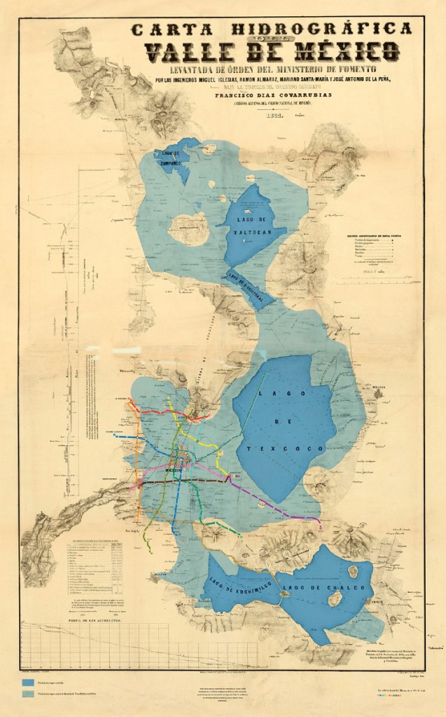
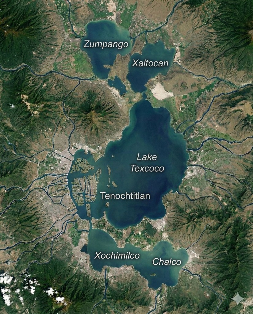
Lake Chalco constantly received fresh water from the rivers of the mountains and from springs. Xochimilco was fed by Lake Chalco and its own springs. Lake Mexico received water from the south and from some seasonal and perennial rivers, and from Lake Texcoco. Finally, Lake Texcoco was the deposit of the waters of all the lakes and torrential rivers (Torres-Alves et al 2020)
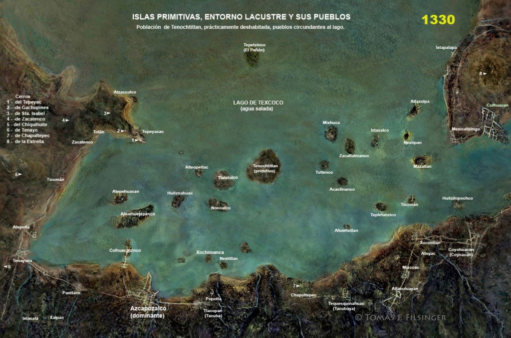
Around 1330, the Aztecs (specifically the Mexica people) were in the very early stages of establishing their civilization in the Valley of Mexico. Having arrived in the region as a nomadic group, they founded their capital city, Tenochtitlan, around 1325 on a marshy island in Lake Texcoco. (1).
- Following the discovery of a freshwater spring in Lake Texcoco at what is now called Chapultepec
The people inhabiting the Basin migrated from mythical ancestral lands over an extended period of time. The genreal order of migration looks something like this….
Xochimilca (c. 900–1000 A.D.): The first to arrive, settling in the southern part of the Valley, establishing their capital at Xochimilco.
Chalca (Chalco): Established themselves east of the Xochimilca.
Tepaneca (late 12th/early 13th century): Settled on the northwest shore of Lake Texcoco, founding Azcapotzalco.
Acolhua (Acolhuaque): Settled on the northeastern shore of Lake Texcoco (near present-day Texcoco).
Tlahuica: Migrated into the modern-day state of Morelos, south of the Valley, though they are often counted among the seven tribes of the region.
Tlaxcaltecans (Tlaxcalans): Settled to the east of the Valley of Mexico, forming a confederation of cities.
Mexica (Aztecs) (c. 1248–1325 A.D.): The last group to arrive. Finding all the good land already claimed, they were forced into undesirable marshlands before founding Tenochtitlan in 1325. These snake ridden, locust infested, undesirable marshlands are in the area known as “Chapultepec” or “Grasshopper Hill”.
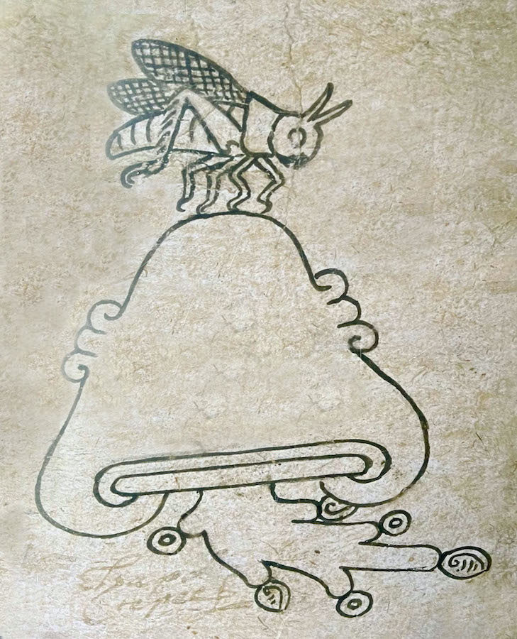
The three symbols that comprise Chapultepec. The word itself comes from “grasshopper” (chapuline) and “on the hill or mountain” (tepec) (1). The glyph shows a little more than the name does. At the bottom of the glyph you can see a symbol for -atl or water
- the word “tepetl” means hill, mountain, rocky precipice; while the word “tepec” denotes a locational placename indicating on (or near to) the hill/mountain
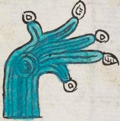
This simplex glyph for water (atl) doubles as the place name, Anenecuilco. The water in question flows upward and bends to the viewer’s right, branching off into five fingers, reminiscent of a hand. White turbinate shells and water droplets/beads appear at the ends of these five streams. The water has the typical turquoise blue coloring, with wavy lines suggesting currents (with one especially thick black line in the middle of the lower part of the stream). At the middle of the glyph the water also swirls, and the artist used the same black lines of current to show this whirlpool.

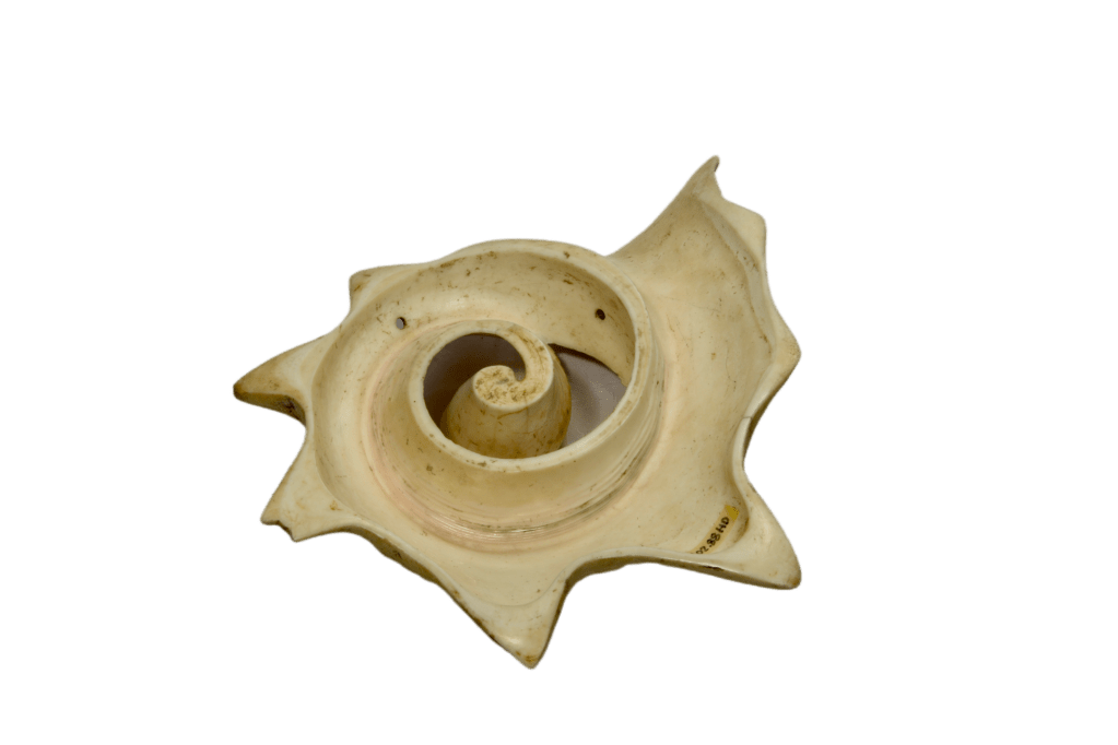
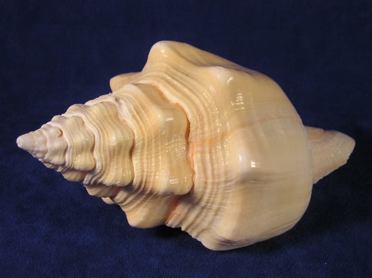
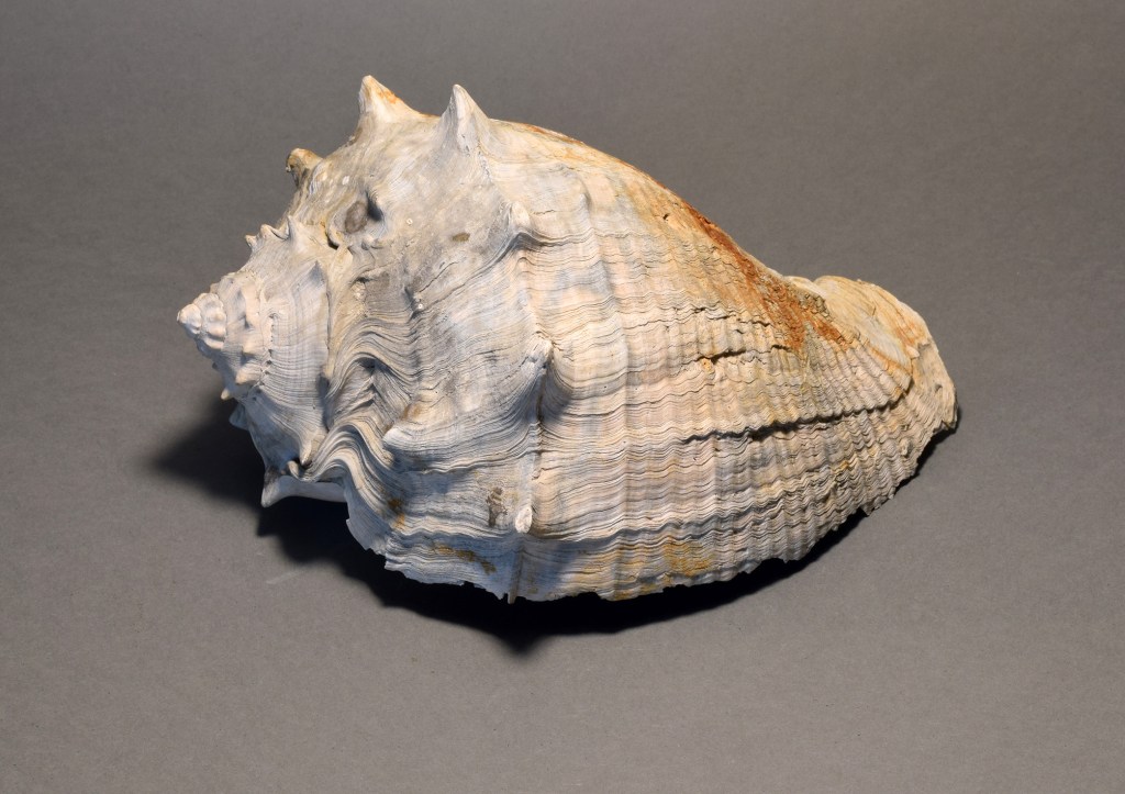
The Aztec shell cozcatl, specifically known as the ehecailacacozcatl (“wind jewel” or “spirally voluted wind jewel”), was a highly symbolic pectoral ornament associated with Quetzalcoatl in his aspect as Ehecatl, the god of wind. It was crafted from a cross-section of a white conch shell, representing the air, breath, and the wind that sweeps the path for the rain gods
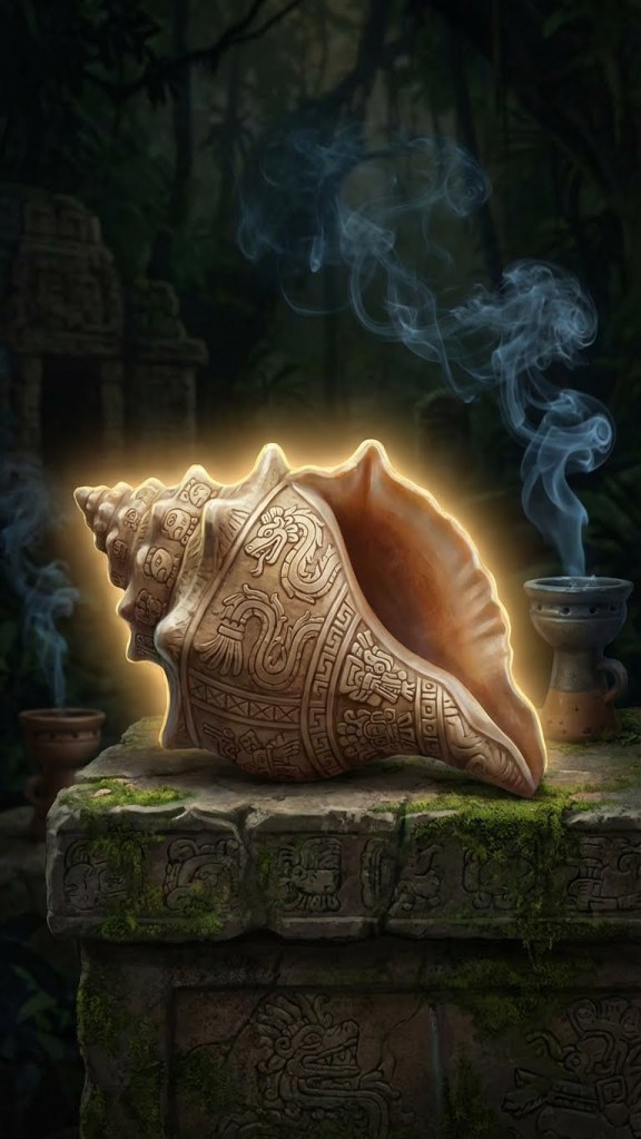
The name that scholars now use to describe this kind of jewel, Ehecacozcatl, derives from the name that Nahuatl-speaking peoples gave to the wind deity, Ehecatl; and cozcatl (1)
- cozcatl : Principal English Translation: necklace, jewel, ornament, jewelry; or, a precious rock made into a rounded shape; or, rosary beads (see Molina, Karttunen, and Lockhart)

The spiral conch, known as the “wind jewel” (ehecacozcatl), was closely associated with the movement of air and spirit, embodying the breath of life. It has been posited that the “wind jewel” (my notation) symbolized patterns witnessed in hurricanes, dust devils, seashells, and whirlpools, which were elemental forces that had significance in the Aztec worlview.
These were crafted from shells of various species including Strombus gigas, Turbinella angulata, and Melongena sp

Some though were fashioned from more valuable materials
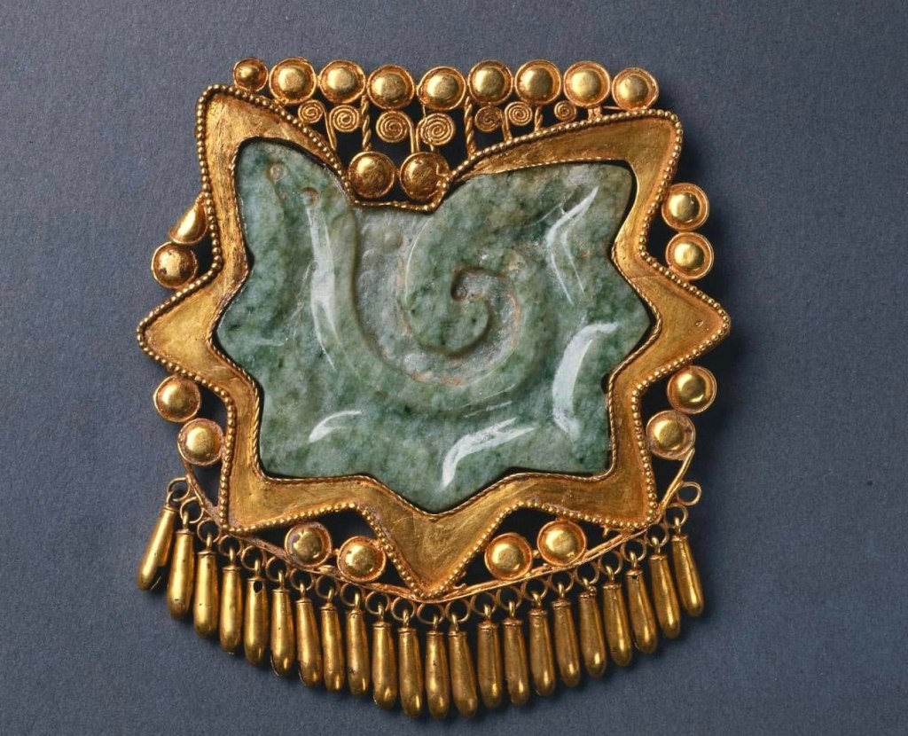
This pendant consists of a conch shell section carved in jade, enclosed in a delicate gold frame with tiny dangling bells. It’s not very big, only 8cm x 7.2 cm (3 1/8 x 2 13/16 in.). This item is currently housed at the Cleveland museum of Art.
Us macehualtin (1) though would likely have to stick with snail shells.
- or macehuales : plural of macehual : the commoner social class (so, us peasants)

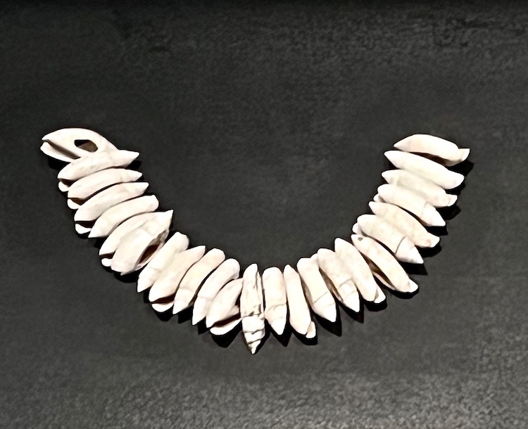
This iconographic example (image on left above) is a closeup of a necklace (cozcatl) made of snail shells (chipolli).
These shells (and other related art/glyphs) were indicative of and symbolic of the importance of their unusually aquatic environment (far more aquatic than that of today) and how the Mexica related to it. Warfare and water stood at the centre of their culture. This is reflected by the individual temples to Huitzilopochtli (War) and Tlaloc (Water) that stood atop the most important construction in Tenochtitlan, the Templo Mayor.
Around 1350, the Aztecs (Mexica) were rapidly consolidating power in the Basin of Mexico following their settlement at Tenochtitlán in 1325. As a developing city-state, they operated within a competitive, often hostile environment of smaller altepetl (kingdoms), relying on alliances, early trade networks, and initial expansion.
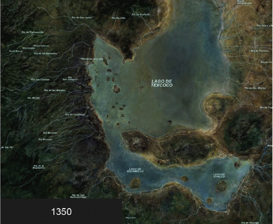
At this stage, the Aztecs were not yet the dominant power; they were still heavily influenced and likely ruled by the stronger Tepanec city-state of Azcapotzalco.
Huitzilihuitl (Hummingbird Feather) began his reign as the second tlatoani (king) of Tenochtitlan around 1390–1396, succeeding his father, Acamapichtli.
Acamapichtli (reigned c. 1376–1395) was the first Huey Tlatoani (“Great Speaker” – essentially the ruler) of the Mexica in Tenochtitlan. As a ruler of both Colhua-Toltec and Mexica descent, he brought political legitimacy to the young city, strengthening it through alliances, infrastructure development, and the establishment of a hereditary monarchy. He was the son of a Mexica leader and a noblewoman from Culhuacan, providing the necessary Toltec ancestry to boost the prestige of the fledgling Tenochtitlan He took power in 1376 after the death of Tenoch. He focused on diplomacy rather than expansionist warfare, marrying into various noble families to secure his position. Under his rule, Tenochtitlan grew in strength, developed chinampa agriculture, and established a more sophisticated urban layout.
Building a city on the lake
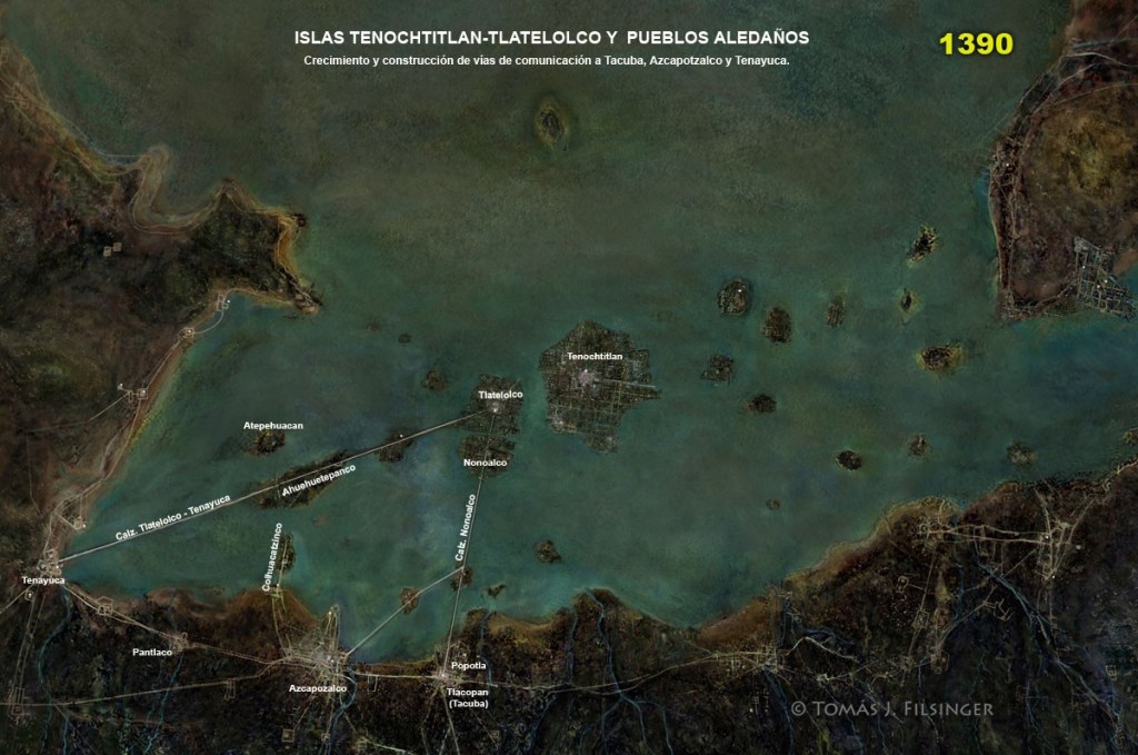
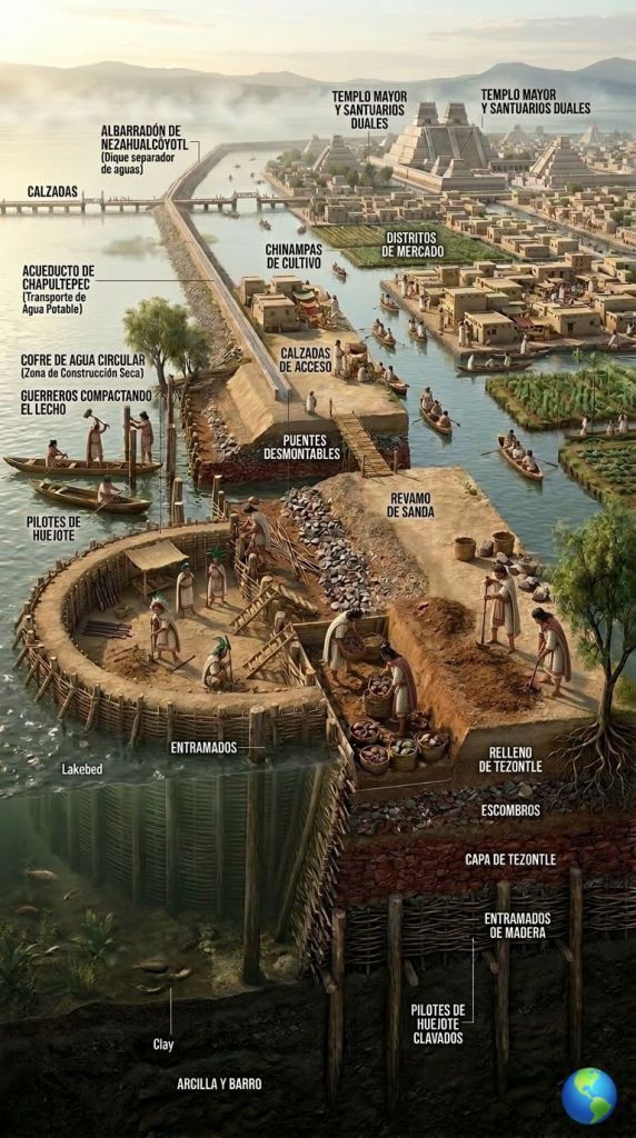
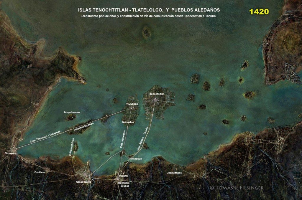
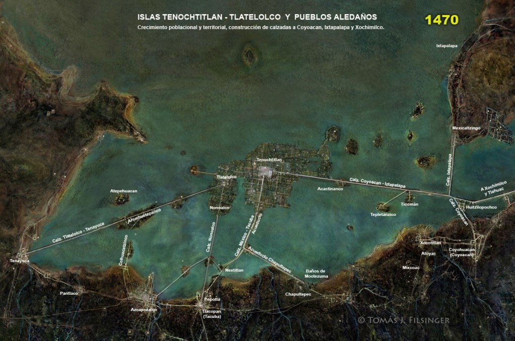
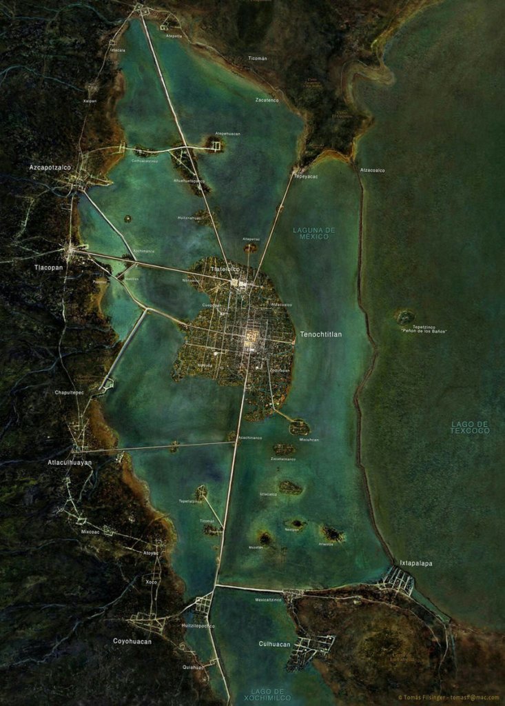
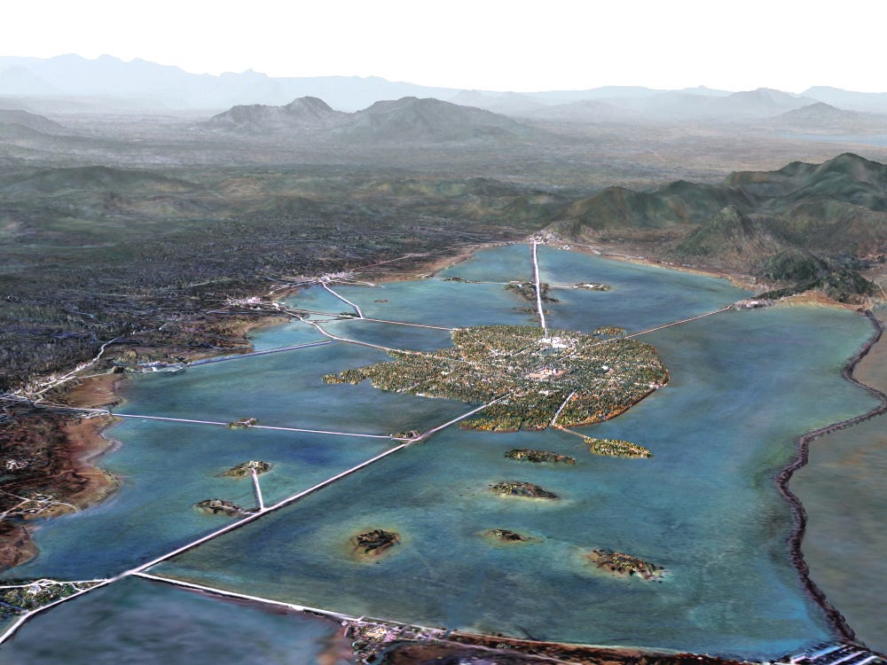
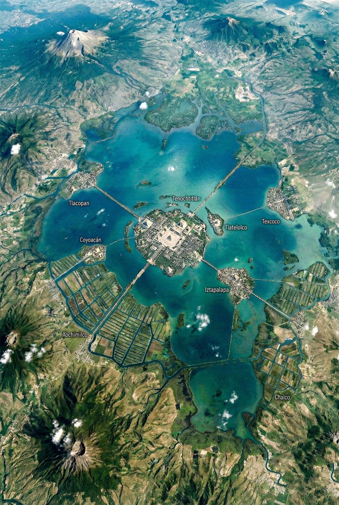
Tenochtitlan, as the Spaniards saw it, appeared to be a single island. It was not. It was a series of five smaller islands that were eventually joined. Starting from the largest island (central yellow circle, above), they extended their land and connected to two other islands by driving log pilings into the lake-bed and filling the space with packed mud taken from the lake. Tlatelolco is the island (yellow circle) to the north, where another Mexica altepetl was established and which Tenochtitlan took over in the early 14th century. The more rectangular island to the west of the central island was along the route to the altepetl, city-state of Tacuba on the western lake shore (Morgado)
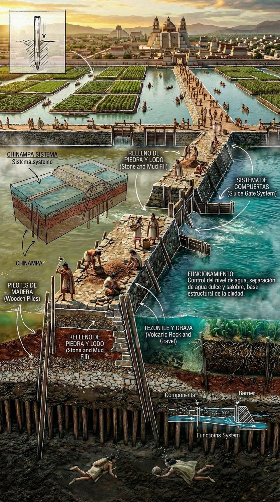
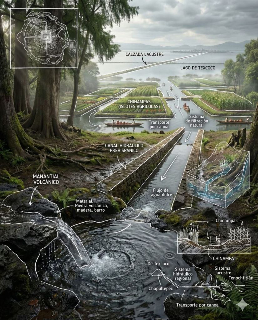
The Aztecs had a complex system of hydraulic structures that was operational until the time of the Spanish conquest. They altered their semiaquatic environment to suit their needs by designing and constructing dykes, walkways, canalized rivers (1), canals, aqueducts, irrigation ditches, drainage works, drawbridges, piers, ponds, pools, chinampas and navigation channels. The purpose of all this construction was to avoid floods, regulate the water levels in the lakes, control the drainage in the catchment, irrigation, navigation, transport, water supply, and even provide a tactical advantage in times of war.
- Canalized rivers are natural waterways engineered into straight, deep, and stable channels, typically using concrete or stone banks, to facilitate navigation and enhance flood control.
Many images in this Post have been garnered from the Community Page of Lo que no sabias on Facebook. Lo que no sabias offers you “paisajes, curiosidades , y de todo un poco” (landscapes, curiosities, and a little bit of everything). This page has many images showing the conceptual drawings of many aspects of Mesoamerica. These images remind me of the “Incredible Cross-Sections” books I loved as a kid.

Around 1420, the Aztecs (specifically the Mexica people of Tenochtitlan) were in a pivotal transitional period, moving from a position of servitude under the Tepanec empire to becoming the dominant power in the Valley of Mexico. This era marked the foundation of the Aztec Triple Alliance and the beginning of rapid imperial expansion
From 1375 until the mid-1420s, the Mexica were vassals to the Tepanec city-state of Azcapotzalco, ruled by Tezozomoc. Following the death of the Tepanec ruler Tezozomoc in 1426, a succession crisis led to chaos. The new Tepanec leader, Maxtla, killed Chimalpopoca, the ruler of Tenochtitlan. In response to Tepanec aggression, Itzcoatl (1), the new leader of Tenochtitlan, formed an alliance with Nezahualcoyotl of Texcoco and the city of Tlacopan. They defeated Azcapotzalco in 1428, marking the true birth of the Aztec Empire (2).
- Itzcoatl. The bastard son of Acamapichtli (the first Huey Tlatoani) and a herb seller in the markets who he found attractive (or so one story goes anyway). See Quelites : Quilitl for more
- and the birth of an “alliance”, a Triple Alliance of groups which is also called Aztec. There can be confusion over this name, Aztec, and its source/meaning. See The Triple Alliance
Construction of the calzadas, the system of dykes and watery causeways, was begun in the 1420s, initially to separate the brackish from the fresh water.

They most likely had openings to manage flows, similar to an agricultural sluice gate. To form the dykes, wood posts were anchored in the shallow lakes and back filled with layers of rock, clay, and a mortar of mud and calcium carbonate (limestone). They required constant maintenance.
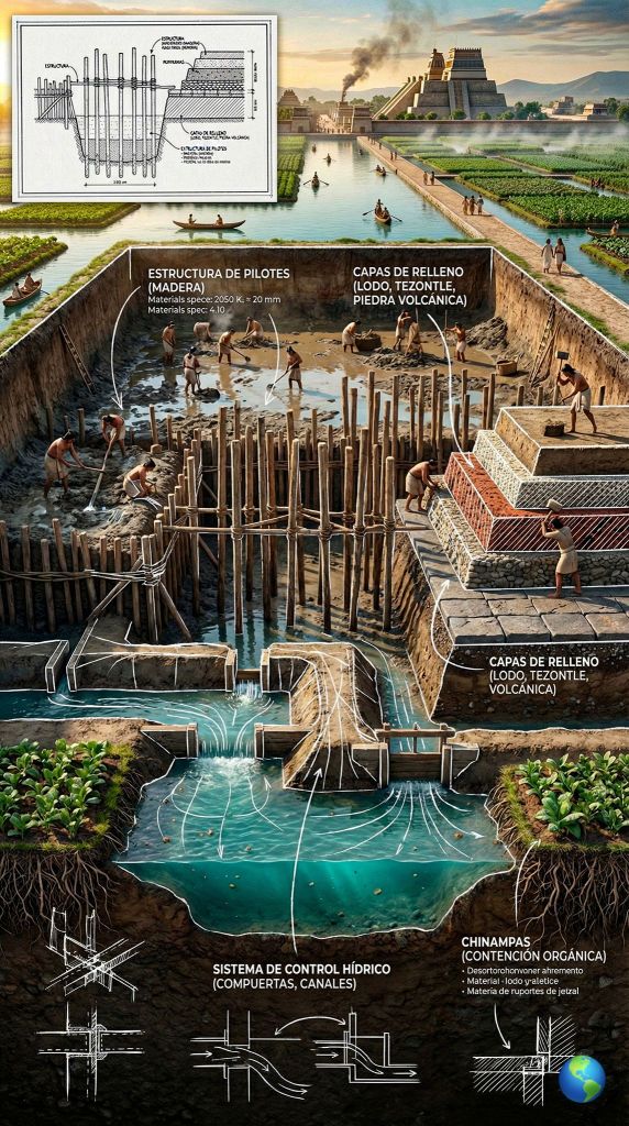
The calzadas (causeways) of Tenochtitlan were wide stone roads, 5 to 7 meters wide and up to 8 km long, built by the Mexica to connect the island city with the mainland,. These causeways also functioned as dykes.
The main ones connected to the north (Tepeyac), west (Tacuba/Tlacopan), and south (Iztapalapa/Tlalpan).
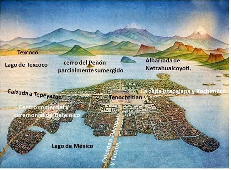
Tepeyac Causeway (Calzada del Tepeyac – North): Connected the centre with the present-day hill of the Villa de Guadalupe.
(Lugo Viñas 2025)
The Tepeyac Causeway connected the city to the north; it was the road that led to Tlatelolco (a powerful commercial center of pre-Hispanic Mexico and twin city of the Aztec capital) and further on (via the present-day Calzada de los Misterios) to Tepeyac Hill (or Tepeyácac).

Iztapalapa Causeway (Calzada de Iztapalapa – South): The route by which Hernán Cortés and his troops entered on November 8, 1519.
Mexico-Tacuba Causeway (Calzada México-Tacuba – West)
Considered the oldest road in the city, it witnessed the “Noche Triste” (Night of Sorrows).
Also referred to as the “Causeway of Cuitlahuac”, the Tlacopan (Tacuba) Causeway ran west from Tenochtitlan, was the one used by Hernán Cortés during his disastrous retreat known as La Noche Triste (The Night of Sorrows) in 1520. This critical path, among others, was the scene of fierce fighting between Spanish forces and the Aztec resistance led by Cuitláhuac, who succeeded Moctezuma II. Cuitláhuac was a determined war leader who refused to allow the Spanish to occupy Tenochtitlan, leading to their expulsion. He reigned as tlatoani (emperor) for only 80 days before dying of smallpox.
The Tacuba Causeway enters the image in the bottom left corner. This road features heavily in the events of La Noche Triste (1) and the legend of Alvarado’s leap. I wont go into it to much except to say that Cortes was out of town dealing with business when one of his minions left in charge, a particularly brutal and cruel swine by the name of Pedro de Alvarado, massacred Aztec nobles and priests observing a religious festival (2). Things rapidly got out of hand and the Spanish were routed from Tenochtitlan. It was the night of greatest loss for the Spanish. The Mexica defended the city by removing the bridges across the causeways and attacking the Spanish from canoes on the lake surrounding them. The Spaniards were weighed down by sacks of stolen gold and many drowned as they leapt across the gaps between the calzadas and missed their footing. This night also generated the (largely defunct) legend of Alvarado’s leap where Pedro used a lance as a makeshift polevault and successfully bridged a gap that should have finished him.
- the “Sad Night” (from a Spaniards point of view). From a Mexicas point of view it’d be called La Noche Victoriosa (the Victorious Night)
- By the day of the festival, twenty days after Cortés’ departure, ( León Portilla 1992 ) the Aztecs had gathered on the Patio of Dances. Alvarado had sixty of his men as well as many of his Tlaxcalan allies stationed in positions around the patio. The Aztecs initiated the Serpent Dance. The euphoric dancing as well as the accompanying flute and drum playing disturbed Alvarado about the potential for revolt. He ordered the gates closed and initiated the killing of many thousands of Aztec nobles, warriors and priests. Alvarado, the conquistadors and the Tlaxcalans retreated to their base in the Palace of Axayacatl and secured the entrances. Alvarado ordered his men to shoot their cannons, crossbows, and arquebuses into the gathering crowd. The result either pre-empted or triggered the Aztec revolt, which was, however, inevitable from the moment of Moctezuma’s capture and was accelerated by the split of the Spanish forces (Levy 2008)
La Noche triste occurred on the night of June 30 – July 1, 1520. Nearly 100 years in the future from the time we’re in now.
Back to the story
This period (1) saw the rise of key figures like Tlacaelel, who helped restructure Aztec society and religion, emphasizing the Mexica as a “chosen people”. The Aztecs began transitioning from mercenaries to a dominant military power.
- 1420 to 1450 (ish)
Following the 1428 (1) victory, the new alliance began expanding rapidly, conquering surrounding city-states like Xochimilco and Culhuacan
- victory over the Tepanec city-state of Azcapotzalco, after the felling of the Tepanec leader, Maxtla (and the foundation of
The Triple Alliance)
1431. The Main Temple of Tenochtitlan is enlarged for the third time. A date glyph “4 Reed,” located at the rear of the pyramid of the Temple of Huitzilopochtli, marks this construction phase. Aztec military expansion throughout the Basin of Mexico progresses rapidly and building activity in Tenochtitlan increases.
1445. Under the ruler Motecuhzoma Ilhuicamina (Montezuma I, r. 1440–69), Aztec imperial domination spreads beyond the Basin. The Aztecs control extensive land, labor, and valuable resources. Several hundred northern city-states are conquered and subject to heavy tribute payments.

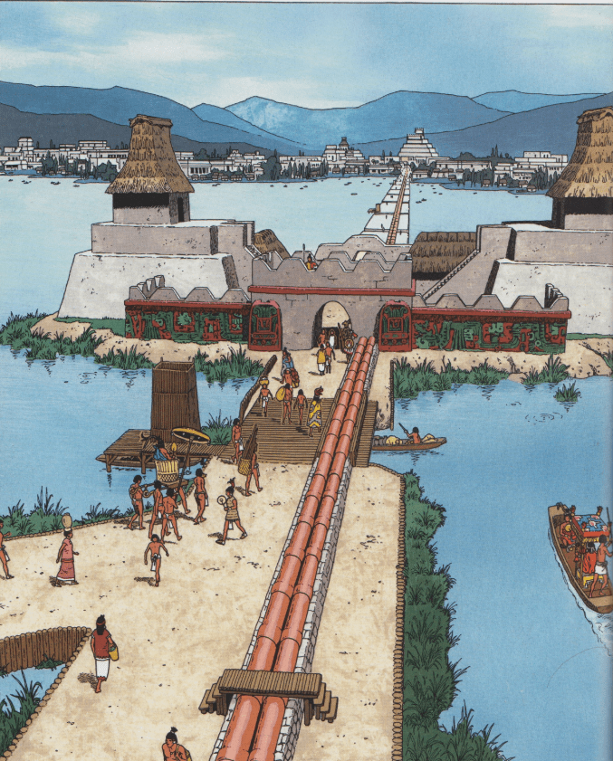
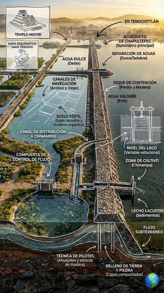
In 1466 Nezahualcóyotl began the construction of another important hydraulic work, the Chapultepec aqueduct system. It supplied fresh spring water to Tenochtitlán. It was not the first aqueduct and was constructed to replace the previous one which had not been as sturdy as required.
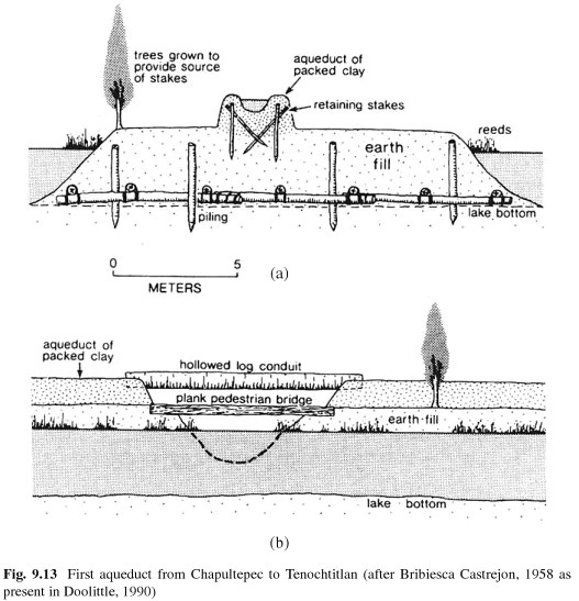
Construction of the previous aqueduct that brought fresh water, suitable for cooking and drinking, from Chapultepec springs to Tenochtitlan began in 1418 (Berdan 2014) under the direction of the Aztec Tlatoani Chimalpopoca. It was 12 km in length, 7 m wide and brought water from Chapultepec directly to the Templo Mayor
Building the aqueducts relied on mud and plant material to create the foundation, which rested on artificial islands that were spread 3 to 4 meters apart. Mounds consisting of mud were constructed on these islands and driven through with a wooden stake for support. The top of each mound had a hollowed out trough lined with compacted clay, and hollowed out logs were placed in the bottom of the flow path to bridge gaps between the islands. A wooden plank walkway flanked the aqueduct, making it easily accessible and created a method of transportation from the city to the outlying areas (Roca 2011)
Once the water reached the city, it was delivered to small reservoirs and select households through a network of canals that extended in the four cardinal directions and branched off to individual streets (Aguilar-Moreno 2007)
The composition of this aqueduct could not withstand the forces of nature (Berdan 2014). Almost 30 years after its construction, the aqueduct of Chapultepec was totally destroyed by the great flood of 1449. Heavy rains triggered a flood that destroyed the aqueduct and effectively shut down Tenochtitlan for weeks (Trowbridge 1919)
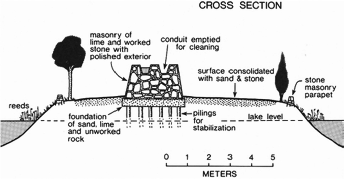
After the destruction of the original aqueduct, the Huey Tlatoani of Texcoco, the warrior-poet Nezahualcoyotl, ordered the construction of another water system using sturdier materials following the same route as the original (Herzog 2006). This aqueduct consisted of two mortar lined troughs made of stone masonry. The addition of the second trough allowed for water to be diverted to the second pipe when maintenance had to be performed on the other. This allowed for a continuous supply of fresh water to be delivered to the city (Becerril 2007), a luxury that many other civilizations of the time never experienced.
Unlike the Romans, the Aztecs also built a wooden walkway along the length of the Chapultepec aqueduct so it was easily cleaned and maintained. This also prevented the spread of disease prevalent with Roman aqueducts (Mitchell 2016) (Karabatos et al 2021)
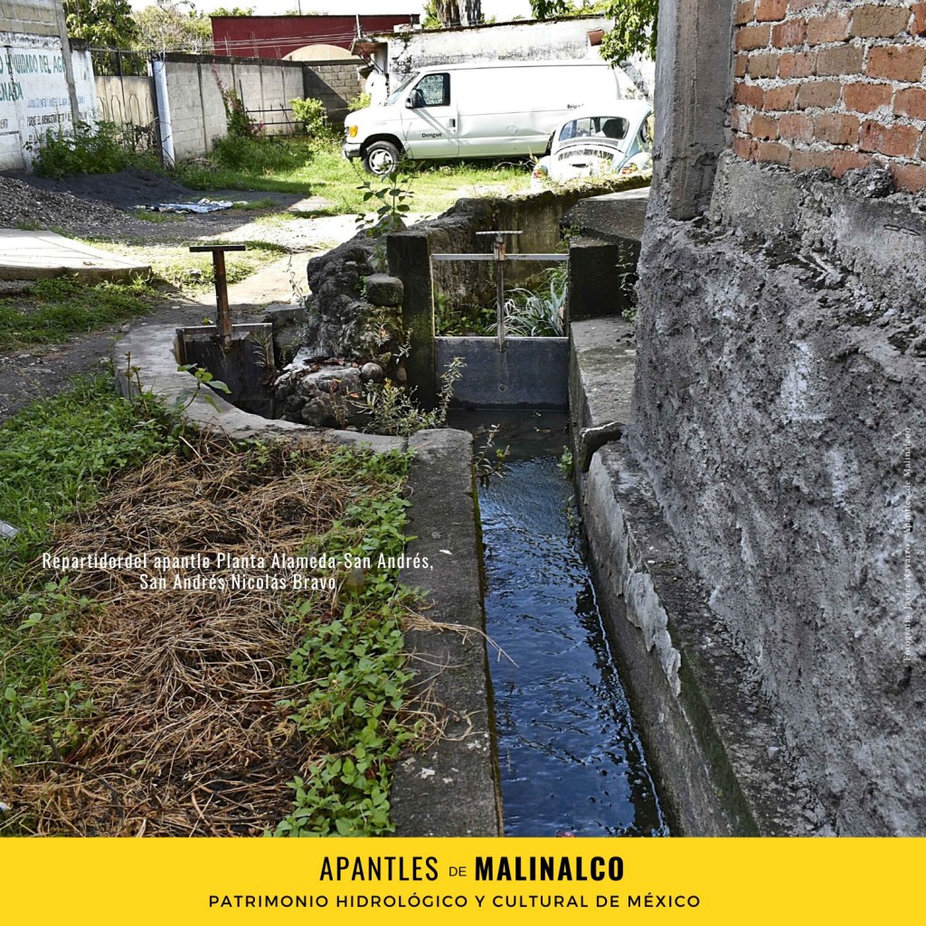
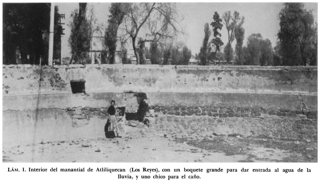
Before the aqueduct system was built, water was supplied by canoe from the springs at Chapultepec (now a large park in the middle of modern Mexico City). Water was distributed through apantles (open pipes) to public fountains and noble houses.
Apantles Today
1469. The Aztec empire continues to grow. At Castillo de Teayo, in the Huastec region of the northern Gulf Coast, an Aztec-style stepped pyramid with a stone temple at its summit is constructed.
Numerous freestanding sculptures, carved in local sandstone, represent Aztec deities and standard bearers.
1473. Tenochtitlan conquers the small island city of Tlatelolco located to its north in Lake Texcoco. The two cities merge, becoming the most densely populated urban center in Mesoamerica. It covers an area of approximately five square miles.
1486. Aggressive expansion takes place under the rulership of Ahuitzotl (r. 1486–1502) when his armies subdue the peoples of the mountainous lands of Guerrero and Oaxaca, substantially extending the tribute domain.
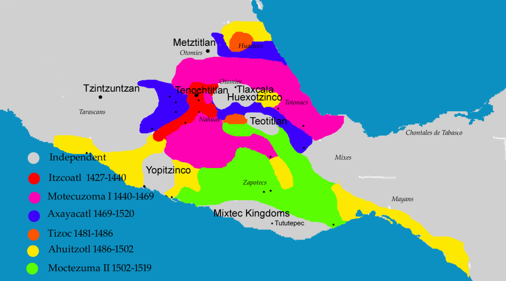
Map showing the expansion of the Mexica empire through the conquests of the various Tlatoani.

1490. The total number of inhabitants in the island city of Tenochtitlan-Tlatelolco may have reached 200,000 or more. The bulk of the urban population are workers, including craft specialists such as potters, goldsmiths, lapidaries, featherworkers, and stonemasons. They produce ceremonial art and luxury goods of the finest quality for use by Aztec nobles in temples and palaces. The most important commercial center of central Mexico is the great market of Tlatelolco.
A second aqueduct was built by Nezahualcóyotl’s successor, Ahuítzotl, around 1500. Although Ahuítzotl had supervised a huge project to rebuild Tenochtitlán, completing the Temple Mayor (the Great Pyramid), the aqueduct project didn’t go so well. At the springs of Coyoacán, Ahuítzotal had a dam and two holding tanks built at elevations necessary to create enough pressure to send water into new aqueducts that joined the existing system. As the story goes, about 40 days after the Coyoacán aqueduct opened, it began to rain. It continued to rain. It poured. The elevated design sent high-pressure floodwaters throughout the city, and, according to some sources, he died when he hit his head on a stone lintel after a dyke broke. The cause of Ahuitzotl’s death in 1502 is disputed though. Other accounts claim that he developed a disease that took his life.
Remnants of Ahuitzotls folly

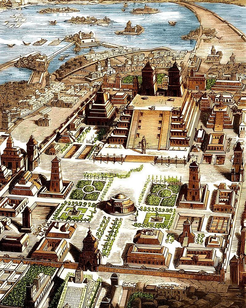
The city was organized in a grid, with canals serving as streets, allowing efficient canoe transport for goods and people throughout the metropolitan area
The layout of the city
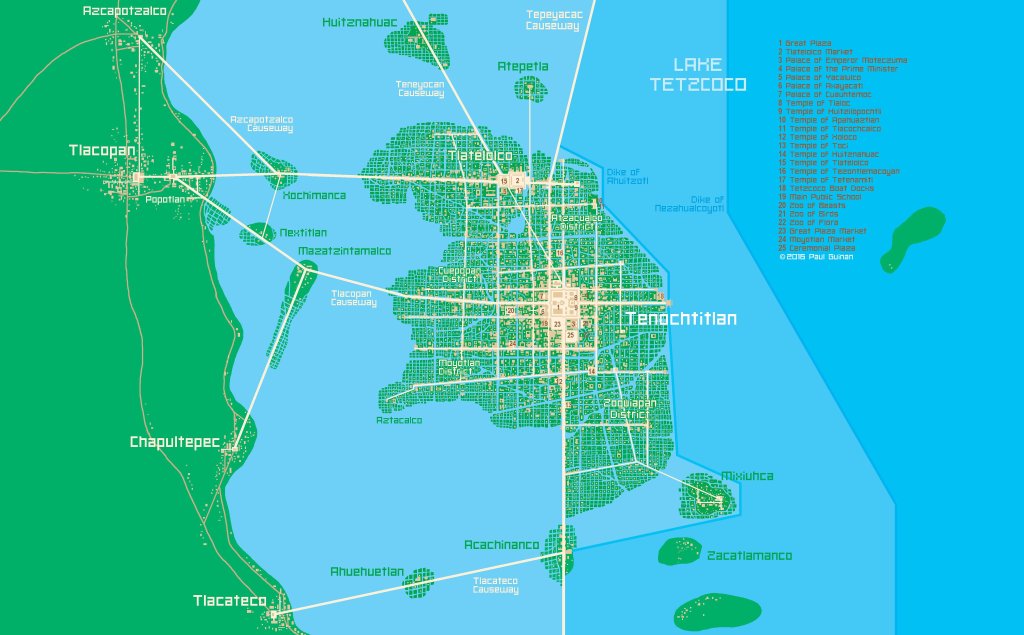
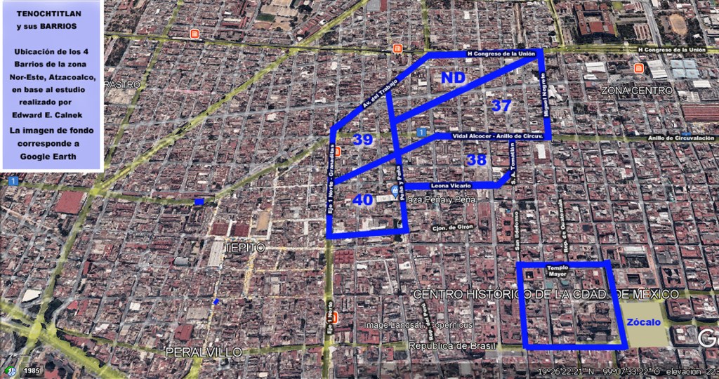
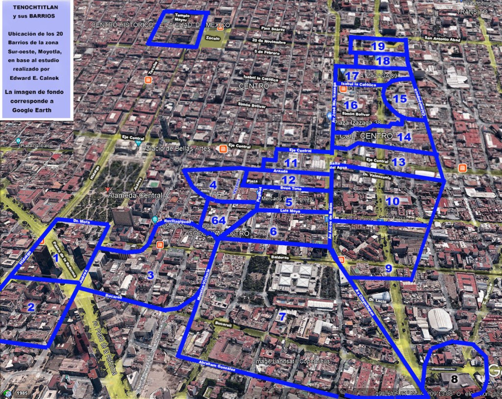
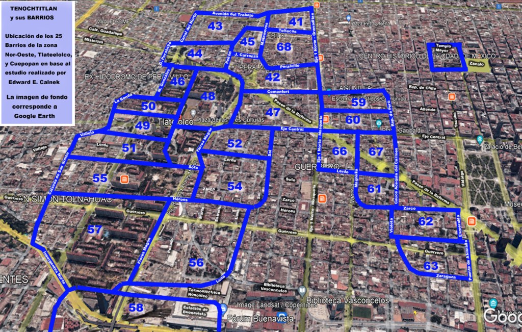
Tenochtitlan was divided into four main residential districts or wards (1) surrounding the central temple precinct each of which was divided into 20 districts (2) (calpulli – singular : calpul) (3). Each calpulli had its own tianquiztli (marketplace), but there was also a main marketplace in Tlatelolco
- Cuepopan (Teopan): “Place where flowers open,” located in the north.; Atzacualco: “In the dyke,” located in the northeast.; Moyotlan: “Place of mosquitoes,” located in the southwest.; Teopan (Teocaltitlan): “Place of the temple,” located in the southeast.
- The city was divided into four main districts, each containing roughly eight calpulli (though sources sometimes note differences in total counts, 20 is the commonly accepted number of primary units).
- Nahuatl for “big house”
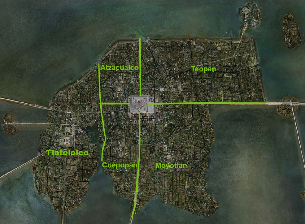
Various calpulli of Tenochtitlan overlaid on the streets of the CDMX.
Atzacualco
Teopan
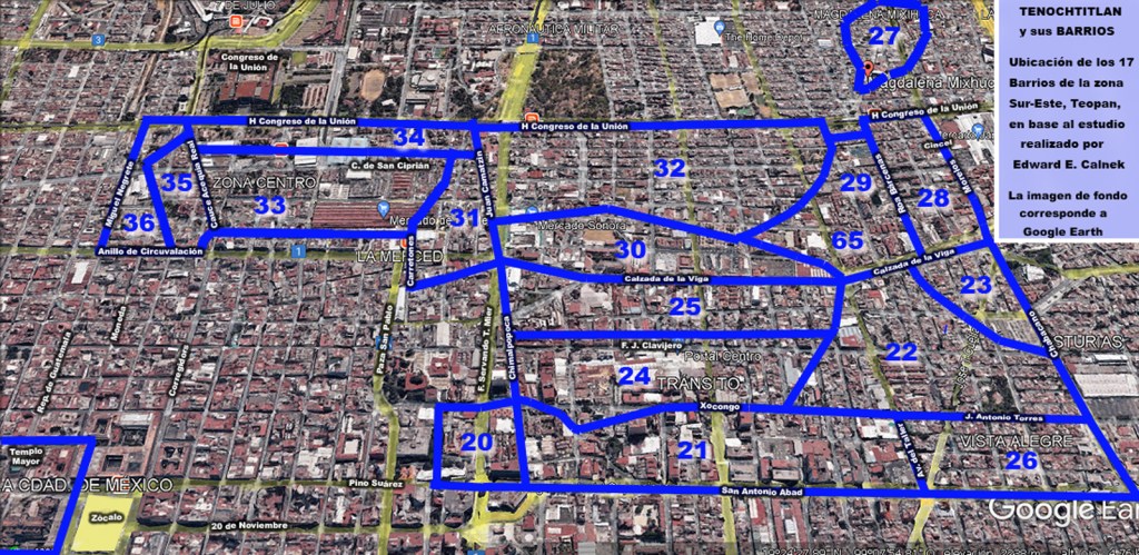
Moyotlan
Cuepopan and Tlatelolco
The calpulli were small rural villages or wards in altepetls (1) or cities and were the fundamental territorial, social, and economic units of Tenochtitlan, functioning as neighbourhoods or districts that organized commoner life and broadly correspond to a city ward or a Spanish “barrio.” Each calpul was led by a council of elders or chiefs who oversaw local administration and managed communal land distribution to families. Calpulli were the base units for organizing labour for public works and agriculture.
People within a calpulli were peasant commoners, but they shared communal farmlands or chinampas. They worked the land or fished, or hired non-connected commoners called macehualtin to work the lands and fish for them. The calpulli paid tribute and taxes to the leader of the altepetl who in turn paid tribute and taxes to the Empire.
They were responsible for collecting taxes (tribute) in goods or labour, which were then delivered to the state.
- In Aztec society, the altepetl were connected and aligned city-states, all of whom were subject to the authorities at whichever city had conquered them
More than a neighbourhood, though, the calpul was a politically-organized, territory-holding group of peasants, who lived near one another in rural villages or in neighbourhoods in larger cities.
Although some calpulli were kin-based, related family groups; others were made up of unrelated members of the same ethnic group, perhaps a migrant community. Others functioned as guilds—groups of artisans who worked gold, or kept birds for feathers or made pottery, textiles, or stone tools. Calpulli that were organized for sculptors, painters, weavers, and embroiderers played significant active roles at ceremonies dedicated to the various deities of the Aztec pantheon. Many of these ceremonies were public affairs, and the calpulli participated actively in those rituals (Ingham 1971)
Calpulli were also places for education. Women were taught to cook, sew, care for children, and work with textiles. The calpul also operated as the Tēlpochcalli (1). Aztec warfare was extremely important and men were expected to go to battle beginning at the age of 15. Aztec warfare was organized so that men would go to fight for their calpul, so they were fighting for their familial pride (Alcock et al 2009)
- schools for young men to learn to be warriors. Commoners could attain high position in society through proficiency in war. Children of nobles went to the calmecac where they would receive rigorous training in history, the calendars, astronomy, religion, economy, law, ethics and warfare
While the calpulli were the lowest class of the organized groups, they were not poor or without influence in the greater Aztec society. Commoners could be instrumental in a significant provincial power struggle. For example, a populist uprising based in a calpulli in Coatlan was successful in calling in the Triple Alliance to help them overthrow an unpopular ruler. Calpulli-based military garrisons were dangerous if their loyalty wasn’t rewarded, and military leaders paid them handsomely to avert massive looting of conquered cities.
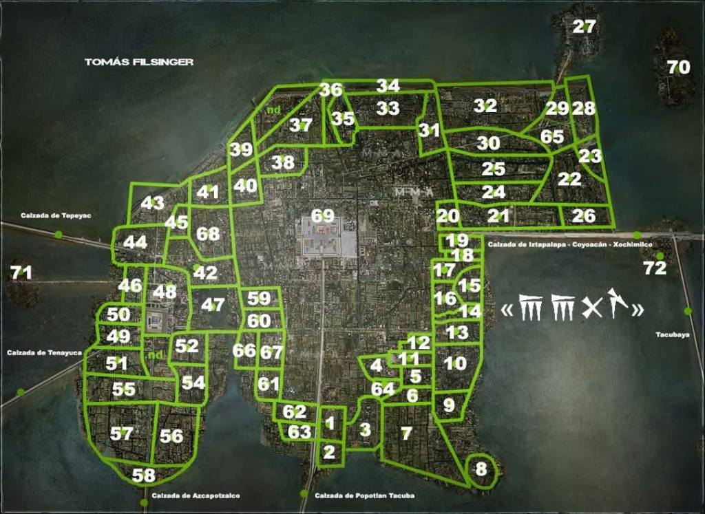
1 – 𝖳𝗓𝖺𝗉𝗈𝗍𝗅𝖺𝗇 𝗈 𝖳𝖾𝗉𝖾𝗊𝗎𝖾𝗁𝗎𝗅𝖺.
𝟤 – 𝖢𝗁𝗂𝖼𝗁𝗂𝗆𝖾𝖼𝖺𝗉𝖺𝗇.
𝟥 – 𝖧𝗎𝖾𝗁𝗎𝖾𝖼𝖺𝗅𝖼𝗈.
𝟦 – 𝖳𝖾𝖼𝗉𝖺𝗇𝖼𝖺𝗅𝗍𝗂𝗍𝗅𝖺𝗇.
𝟧 – 𝖳𝖾𝗈𝖼𝖺𝗅𝗍𝗂𝗍𝗅𝖺𝗇 𝗈 𝖳𝖾𝖼𝗎𝗂𝖼𝖺𝗅𝗍𝗂𝗍𝗅𝖺𝗇.
𝟨 – 𝖳𝖾𝗊𝗎𝗂𝖼𝖺𝗅𝗍𝗂𝗍𝗅𝖺𝗇-𝖳𝗅𝖺𝗆𝖺𝗍𝗓𝗂𝗇𝖼𝗈.
𝟩 – 𝖠𝗍𝗅𝖺𝗆𝗉𝖺.
𝟪 – 𝖠𝗓𝗍𝖺𝖼𝖺𝗅𝖼𝗈.
𝟫 – 𝖳𝗅𝖺𝗅𝖼𝗈𝖼𝗈𝗆𝗈𝗅𝖼𝗈 𝗈 𝖳𝗅𝖺𝖼𝗈𝖼𝗈𝗆𝗎𝗅𝖼𝗈.
𝟣𝟢 – 𝖠𝗆𝖺𝗇𝖺𝗅𝖼𝗈 (𝖯𝗈𝖼𝗁𝗍𝗅𝖺𝗇 𝖠𝗆𝖺𝗇𝖺𝗅𝖼𝗈).
𝟣𝟣 – 𝖢𝗂𝗁𝗎𝖺𝗍𝖾𝗈𝖼𝖺𝗅𝗍𝗂𝗍𝗅𝖺𝗇.
𝟣𝟤 – 𝖸𝗈𝗉𝗂𝖼𝗈.
𝟣𝟥 – 𝖳𝖾𝗉𝖾𝗍𝗂𝗍𝗅𝖺𝗇.
𝟣𝟦 – 𝖠𝗍𝗂𝗓𝖺𝗉𝖺𝗇.
𝟣𝟧 – 𝖷𝗂𝗁𝗎𝗂𝗍𝗈𝗇𝗀𝗈.
𝟣𝟨 – 𝖳𝗅𝖺𝗍𝗂𝗅𝖼𝗈.
𝟣𝟩 – 𝖳𝖾𝗊𝗎𝗂𝗑𝗊𝗎𝗂𝗉𝖺𝗇.
𝟣𝟪 – 𝖭𝖾𝖼𝖺𝗍𝗂𝗍𝗅𝖺𝗇.
𝟣𝟫 – 𝖷𝗈𝗅𝗈𝖼𝗈 (𝖳𝗅𝖺𝖼𝗁𝖼𝗈𝖺𝖼).
𝟤𝟢 – 𝖢𝗎𝖾𝗓𝖼𝗈𝖼𝗈𝗇𝗍𝗂𝗍𝗅𝖺𝗇.
𝟤𝟣 – 𝖠𝖼𝖺𝗍𝗅𝖺𝗇.
𝟤𝟤 – 𝖳𝗈𝗅𝗍𝖾𝗇𝖼𝗈.
𝟤𝟥 – 𝖮𝗍𝗅𝗂𝖼𝖺 (𝖸𝖺𝗈𝗍𝗅𝗂𝖼𝖺).
𝟤𝟦 – 𝖠𝗍𝖾𝗉𝗈𝗇𝖺𝗓𝖼𝗈.
𝟤𝟧 – 𝖳𝗅𝖺𝖼𝗁𝖼𝗎𝗂𝗍𝗂𝗍𝗅𝖺𝗇.
𝟤𝟨 – 𝖬𝖺𝗅𝖼𝗎𝗂𝗍𝗅𝖺𝗉𝗂𝗅𝖼𝗈.
𝟤𝟩 – 𝖬𝗂𝗑𝗂𝗁𝗎𝖼𝖺𝗇.
𝟤𝟪 – 𝖹𝖺𝖼𝖺𝗍𝗅𝖺𝗇.
𝟤𝟫 – 𝖳𝗓𝗈𝗊𝗎𝗂𝖺𝗉𝖺𝗇 (𝖹𝗈𝗊𝗎𝗂𝖺𝗉𝖺𝗇).
𝟥𝟢 – 𝖧𝗎𝗂𝗍𝗓𝗇𝖺𝗁𝗎𝖺𝗍𝗈𝗇𝖼𝗈.
𝟥𝟣 – 𝖳𝖾𝗆𝗓𝖼𝖺𝗅𝗍𝗂𝗍𝗅𝖺𝗇.
𝟥𝟤 – 𝖮𝖼𝖾𝗅𝗈𝗍𝗓𝗈𝗇𝗍𝖾𝖼𝗈𝗅𝗍𝗂𝗍𝗅𝖺𝗇.
𝟥𝟥 – 𝖮𝗆𝖾𝗍𝗈𝖼𝗁𝗍𝗂𝗍𝗅𝖺𝗇.
𝟥𝟦 – 𝖠𝗍𝗅𝗂𝗑𝖼𝗈.
𝟥𝟧 – 𝖢𝗎𝖺𝗎𝗁𝖼𝗈𝗇𝗍𝗓𝗂𝗇𝖼𝗈 (𝖢𝗈𝗇𝗍𝗓𝗂𝗇𝖼𝗈).
𝟥𝟨 – 𝖳𝗈𝗓𝖼𝖺𝗆𝗂𝗇𝖼𝖺.
𝟥𝟩 – 𝖳𝗈𝗆𝖺𝗍𝗅𝖺𝗇.
𝟥𝟪 – 𝖢𝗈𝖺𝗍𝗅𝖺𝗇.
𝟥𝟫 – 𝖹𝖺𝖼𝖺𝗍𝗅𝖺𝗇.
𝟦𝟢 – 𝖢𝗎𝗂𝗍𝗅𝖺𝗁𝗎𝖺𝗍𝗈𝗇𝖼𝗈.
𝟦𝟣 – 𝖬𝖾𝖼𝖺𝗆𝖺𝗅𝗂𝗇𝖼𝗈.
𝟦𝟤 – 𝖠𝗍𝖾𝗇𝖺𝗇𝗍𝗂𝗍𝖾𝖼𝗁.
𝟦𝟥 – 𝖠𝗍𝖾𝗇𝖺𝗇𝗍𝗂𝗍𝗅𝖺𝗇.
𝟦𝟦 – 𝖳𝖾𝗅𝗉𝗈𝖼𝗁𝖼𝖺𝗅𝗍𝗂𝗍𝗅𝖺𝗇.
𝟦𝟧 – 𝖠𝗉𝗈𝗁𝗎𝖺𝖼𝖺𝗇.
𝟦𝟨 – 𝖠𝗍𝖾𝖼𝗈𝖼𝗈𝗅𝖾𝖼𝖺𝗇 (𝖠𝗓𝗈𝖼𝗈𝖼𝗈𝗅𝖺𝖼𝖺𝗇).
𝟦𝟩 – 𝖠𝗍𝖾𝗓𝖼𝖺𝗉𝖺𝗇.
𝟦𝟪 – 𝖳𝗅𝖺𝗍𝖾𝗅𝗈𝗅𝖼𝗈.
𝟦𝟫 – 𝖧𝗎𝖾𝗒𝗉𝖺𝗇𝗍𝗈𝗇𝖼𝗈.
𝟧𝟢 – 𝖳𝖾𝗉𝗂𝗍𝗈𝗇.
𝟧𝟣 – 𝖢𝖺𝗉𝗈𝗅𝗍𝗂𝗍𝗅𝖺𝗇.
𝟧𝟤 – 𝖢𝗈𝖺𝗍𝗅𝖺𝗇.
𝟧𝟥 – 𝖷𝗈𝗅𝖺𝗉𝖺𝗇.
𝟧𝟦 – 𝖠𝖼𝗈𝗓𝖺𝖼.
𝟧𝟧 – 𝖳𝗅𝖺𝗑𝗈𝗑𝗂𝗁𝗎𝖼𝗈.
𝟧𝟨 – 𝖳𝗈𝗅𝗊𝗎𝖾𝖼𝗁𝗂𝗎𝗁𝖼𝖺𝗇.
𝟧𝟩 – 𝖨𝗓𝗍𝖺𝗍𝗅𝖺𝗇.
𝟧𝟪 – 𝖭𝗈𝗇𝗈𝖺𝗅𝖼𝗈.
𝟧𝟫 – 𝖢𝗈𝗅𝗁𝗎𝖺𝖼𝖺𝗍𝗓𝗈𝗇𝖼𝗈 (𝖢𝗈𝗅𝗁𝗎𝖺𝖼𝖺𝗍𝗈𝗇𝖼𝗈).
𝟨𝟢 – 𝖳𝖾𝗓𝖼𝖺𝗍𝗓𝗈𝗇𝖼𝗈.
𝟨𝟣 – 𝖠𝗇𝖺𝗅𝖼𝗈 (𝖠𝗇𝖺𝗅𝗉𝖺).
𝟨𝟤 – 𝖳𝖾𝗈𝖼𝖺𝗅𝗍𝗂𝗍𝗅𝖺𝗇.
𝟨𝟥 – 𝖠𝗍𝗅𝖺𝗆𝗉𝖺.
𝟨𝟦 – 𝖳𝗅𝖺𝗑𝗂𝗅𝗉𝖺
𝟨𝟧 – 𝖳𝗈𝗅𝗍𝖾𝗇𝖼𝗈.
𝟨𝟨 – 𝖢𝗈𝗉𝗈𝗅𝖼𝗈.
𝟨𝟩 – 𝖢𝗎𝖾𝗉𝗈𝗉𝖺𝗇.
𝟨𝟪 – 𝖳𝖾𝖼𝗈𝖺𝗅𝗍𝗂𝗍𝗅𝖺𝗇.
𝟨𝟫 – 𝖱𝖾𝖼𝗂𝗇𝗍𝗈 𝖢𝖾𝗋𝖾𝗆𝗈𝗇𝗂𝖺𝗅 𝖽𝖾𝗅 𝖳𝖾𝗆𝗉𝗅𝗈 𝖬𝖺𝗒𝗈𝗋.
𝟩𝟢 – 𝖹𝖺𝗉𝖺𝗍𝗅𝖺𝗆𝖺𝗇𝖼𝗈.
𝟩𝟣 – 𝖠𝗅𝗍𝖾𝗈𝗉𝖾𝗍𝗅𝖺𝖼.
𝟩𝟤 – 𝖠𝖼𝖺𝖼𝗍𝗂𝗇𝖺𝗇𝖼𝗈.
1519. Hernán Cortés (1485–1547) and about 500 soldiers land near the modern town of Cempoala. They are met by Motecuhzoma II’s emissaries, who offer exotic gifts including elaborate costumes, feather fans and headdresses, and jewelry of shell, turquoise, jade, and gold, hoping to prevent the strangers from continuing to the imperial city. Cortés is also given a young woman named Malintzin or Malinche. Speaking both Nahuatl, the language of central Mexico, and Chontal Maya, spoken on the coast, she becomes his translator, confidante, and consort. On August 16, Cortés and his small army set off for Tenochtitlan.
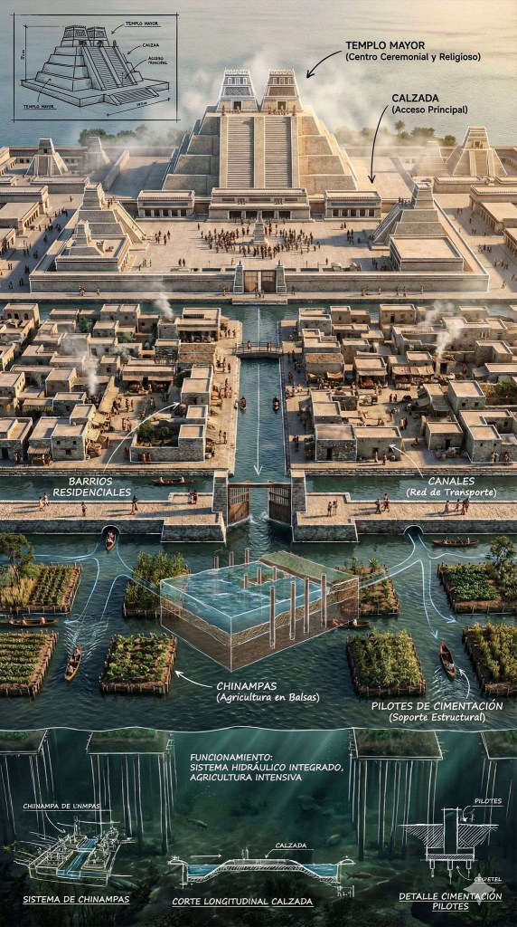
The city was connected to the mainland via broad, solid causeways designed with movable, bridges to allow for defense and boat traffic.
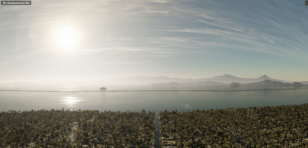
Nezahualcoyotls Dyke
The most amazing piece of engineering for Tenochtitlan was the Nezahualcoyotl Dyke, which split the salt waters of Lake Texcoco from the fresh waters of Lake Tenochtitlan.
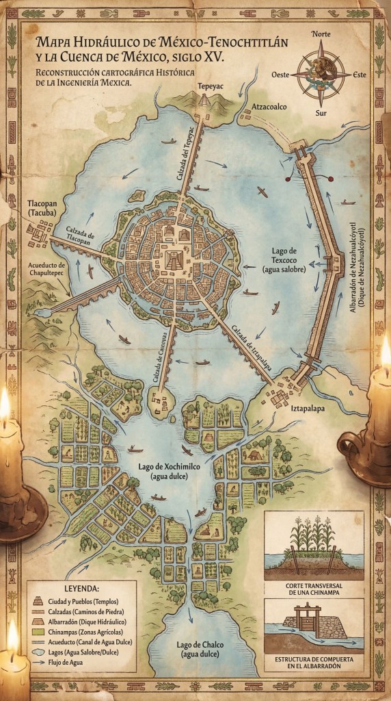
The Aztec capital was located in the freshwater portion of the two lakes, seated on a defensible and large island. The dike had a length of approximately 16 km, a height of 8 m and a width of 3.5 m. For a structure of that size, it would take an average person just over three hours to fully traverse the dyke from end to end. The dyke typically kept the water level on the freshwater side about two meters (about 10 feet) above the saltwater lake on the opposite side. The structure provided flooding control and desalination of the freshwater portion of the once-combined lake.
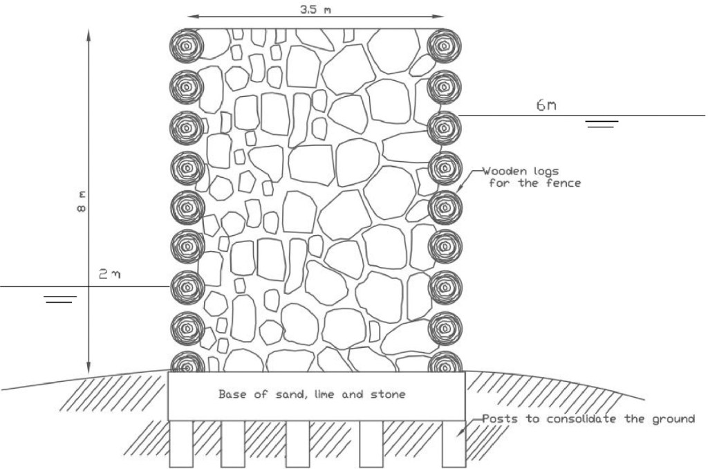
“Thick wooden piles were stuck to the ground forming a hollow fence, inside the fence, big rocks and sand were deposited between the piles.”
From the time of the construction of the Nezahualcoyotl dike until the arrival of the Spanish conquerors (70 years approximately) there is no mention in the historical records of floods in the city of Tenochtitlan due to an increase of water level in Lake Texcoco. However, after the conquest, the Nezahualcoyotl dike was damaged and later destroyed and the city was flooded numerous times throughout the next 350 years (SACMEX)

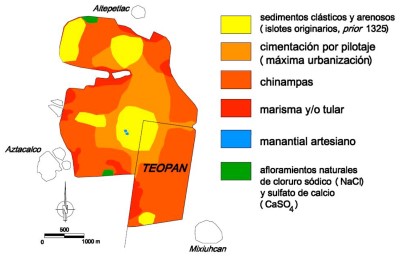
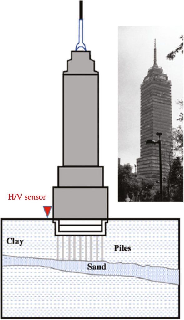
The city was constructed on soft lakebeds, utilizing long wooden pylons to stabilize heavy,, stone, buildings, such as the Templo Mayor.
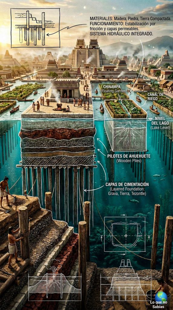
This type of construction was utilised in the design of the Torre Latinoamericana (at that time the tallest building in Mexico City)

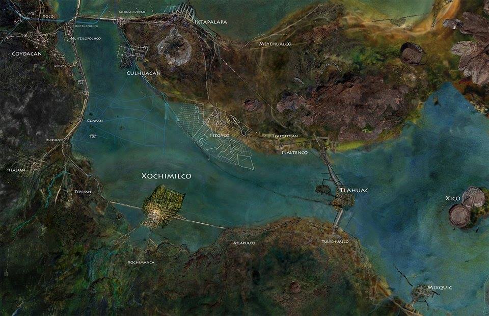
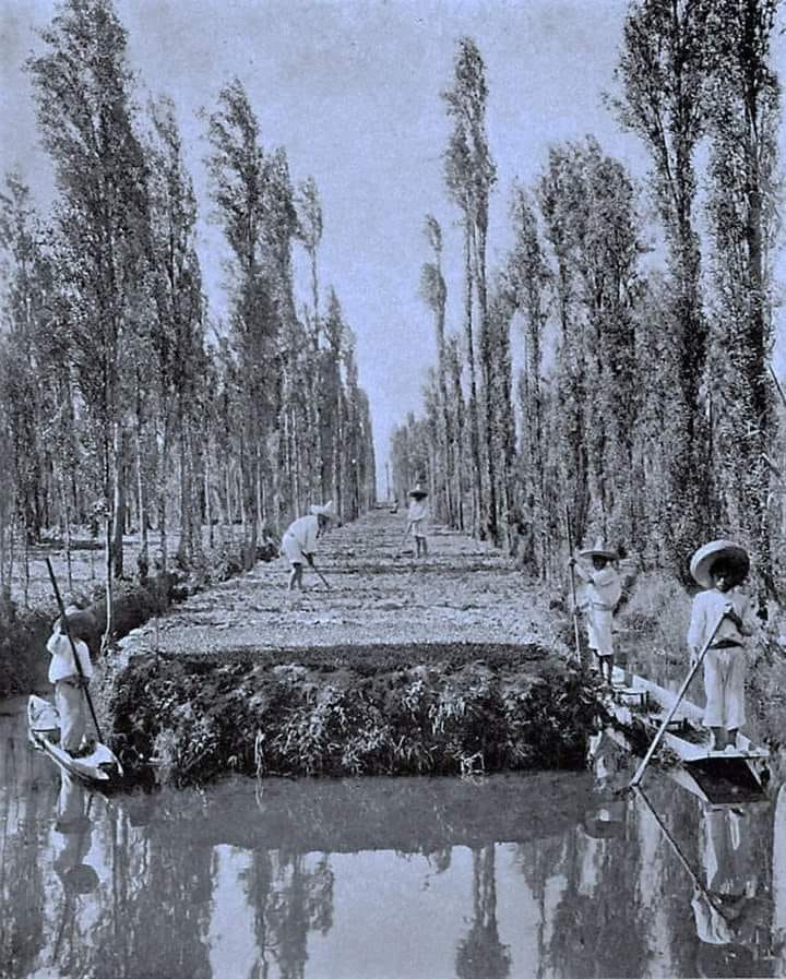
Xochimilca and the building of Xochimilco
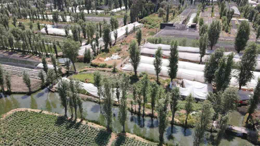
Chinampas

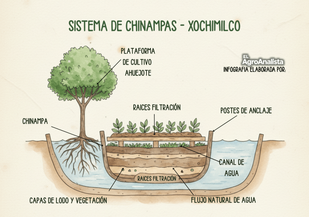
Chinampas are highly productive, artificial agricultural islands built in shallow lakes and swamps of the Valley of Mexico. These highly arable market gardens are created by layering organic matter, mud, and reeds to form fertile plots.
Surrounded by canals for irrigation and transport chinampas allowed for multiple harvests annually and effectively fed large populations (1).
- Population figures for Tenochtitlan are a bit iffy. Numbers range from 60,000 (too low in my opinion) to 400,000 (which many scholars will claim as ludicrously high but I’m inclined to think that on festival days the citys population swelled to this or higher) and most think it safe to estimate 150 to 200 thousand
This system of agriculture was widely use in Mexico. In the area of Xaltocan, in which traditionally historians and archaeologists have classified Lake Xaltocan as a saline lake, chinampa agriculture may have started as early as 200AD (Morehart 2016). The system of chinampas in Lake Xaltocan is estimated to have covered approximately 1,500 hectares, with 1,000 hectares of arable land. Using data on the size and density of the archaeological site it was estimated that a local population of 5,000 people, requiring 1,000,000 kg of maize per year populated this area. The chinampas are estimated to have produced 3,000 kg per hectare and 3,000,000 kg per year. In other words, this suggests a surplus of 2,000,000 kg of maize for the entire population.
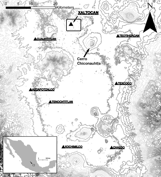
In the fifteenth century, however, the river feeding this area was diverted to the north, and the springs were diverted to provide water for Mexico City. Now this lake has been entirely drained and the chinampa system has been buried.
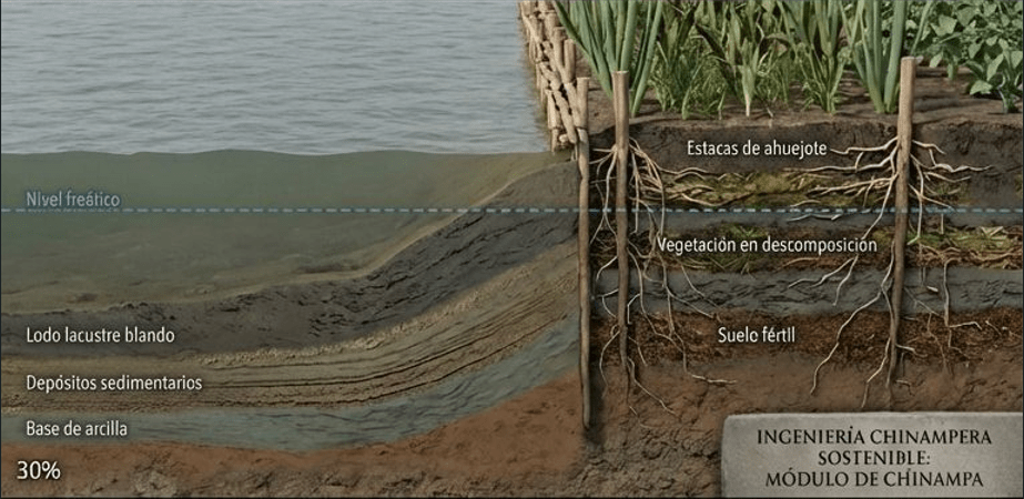
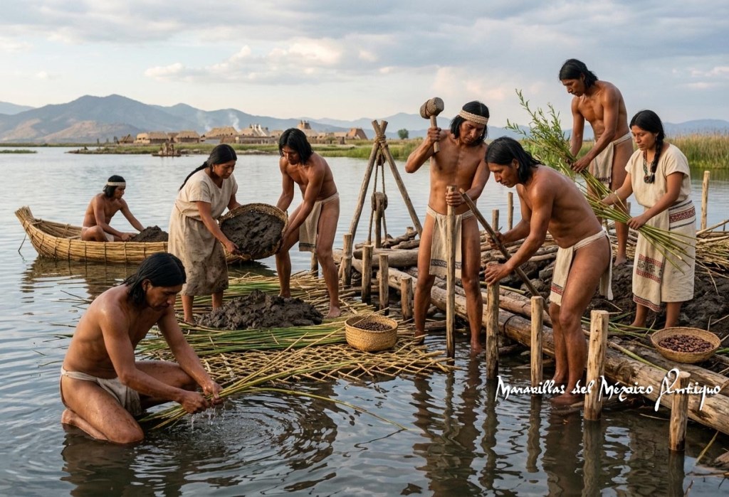
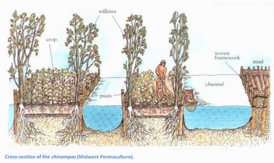
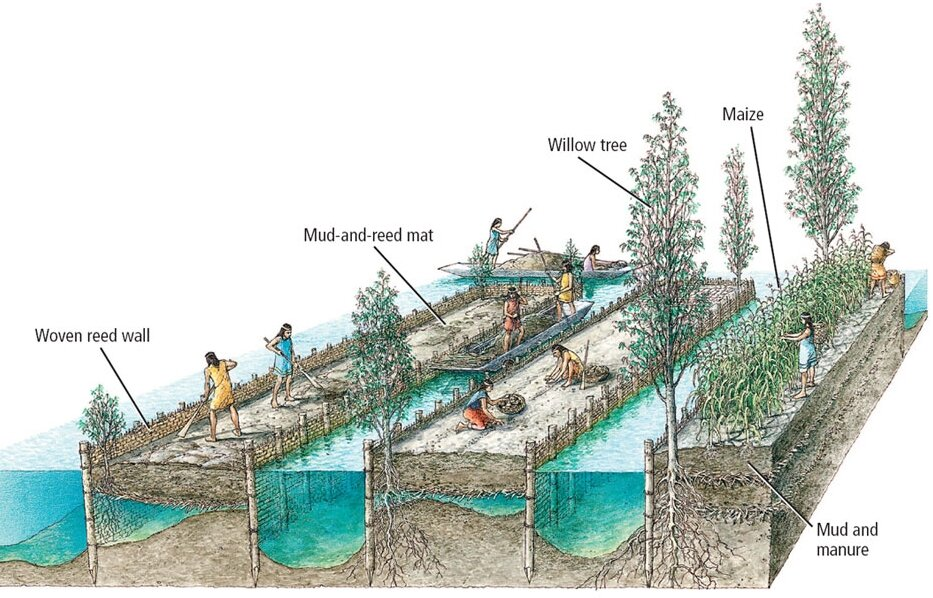
The construction process of a chinampa began with the creating a rectangle shaped island in shallow water. To do this, wooden stakes—frequently from the ahuejote tree (Salix bonplandiana)—were driven into the ground to form a perimeter.
Note the cross section of the chinampa in the image above (left). You can see how earth/mud and plant material have been layered to create the chinampa.
These stakes not only marked out the space but also took root over time, consolidating the structure. Branches and aquatic vegetation were interwoven among them, creating a kind of permeable “box.” Subsequently, the interior was filled with alternating layers of mud from the lakebed, plant remains, and decomposing organic matter.
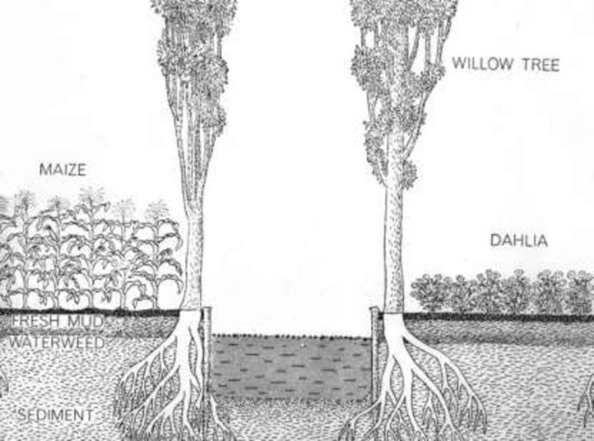
This process was repeated systematically and generated highly fertile, nutrient-rich soils reclaimed from beneath the water of the lake and in some cases, as with Xaltocan, rehabilitated saline soils into arable farming land. Studies of chinampa soils conducted by researchers like William T. Sanders have confirmed the extraordinary productivity of this system which was (and still is) capable of sustaining multiple harvests annually.
Chinampas are often called “floating gardens” and although a lovely terminology it is not correct. The gardens did not float but were firmly anchored to the ground by ahuejote trees. These trees also stabilised the boundaries of the chinampa fields preventing them from eroding back into mud and settling on the lake floor. The image above is waaaay out. Aside from the inaccuracy of the chinampa bed the tree is growing in the water (?). The three images a little above this one are more indicative of the construction of the chinampa.
So. Long story short….
How chinampas are constructed
- Stake Out Plots: Rectangular areas are marked out in shallow lake beds using willow stakes.
- Weave a Container: Reeds and branches (wattle) are woven between the stakes to form a container. (this is often referred to as a “chinamitl”)
- Layer Materials: The enclosure is filled with lake-bottom mud, decaying vegetation, and organic debris.
- Anchor with Willows: Willow trees are planted at the corners; their roots help stabilize the chinampa and the stakes sprout to reinforce the edges.
- Create Canals: Canals are dug between the plots, creating a network for canoes and providing water supply to the gardens. Canals are also made by digging out the lake bed to create these artificial islands.
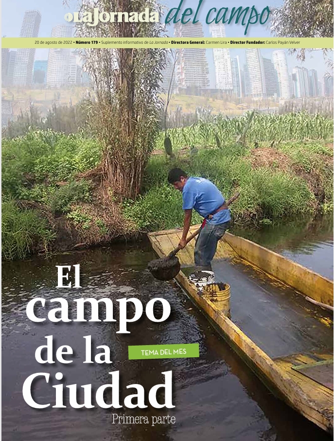
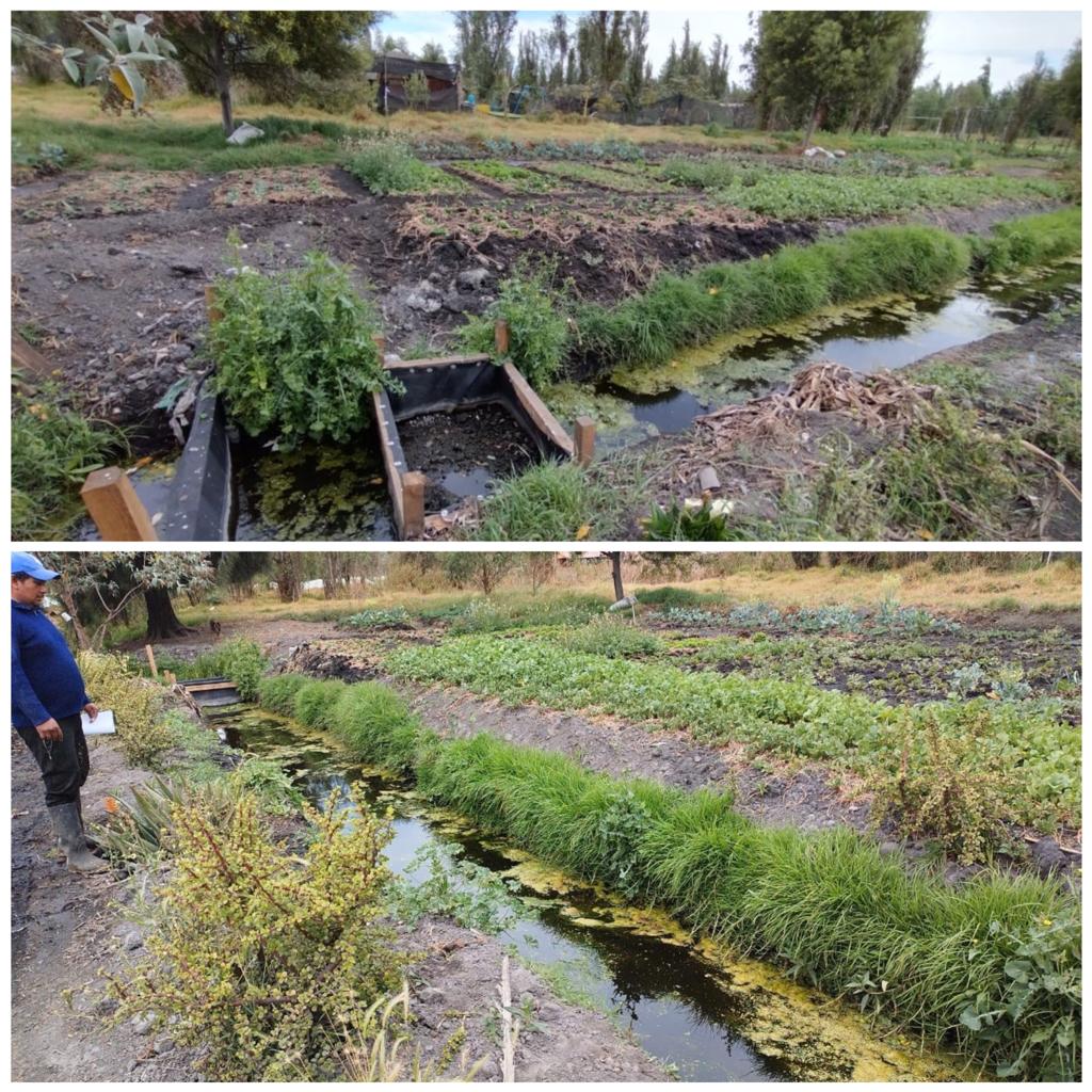
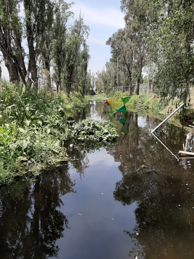
The chinampas have been subject to degradation by urban pollution but this has turned around in the last couple of decades primarily due to the danger of the extinction of the indigenous axolotl.


See Xochimilco and the Axolotl for more on this little critter.
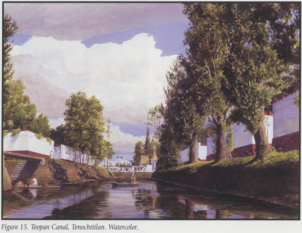
The canals of Tenochtitlan/CDMX
A number of canals from the time of the Mexica were retained and made into major routes for goods to arrive in the city.
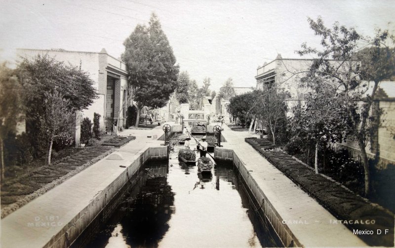
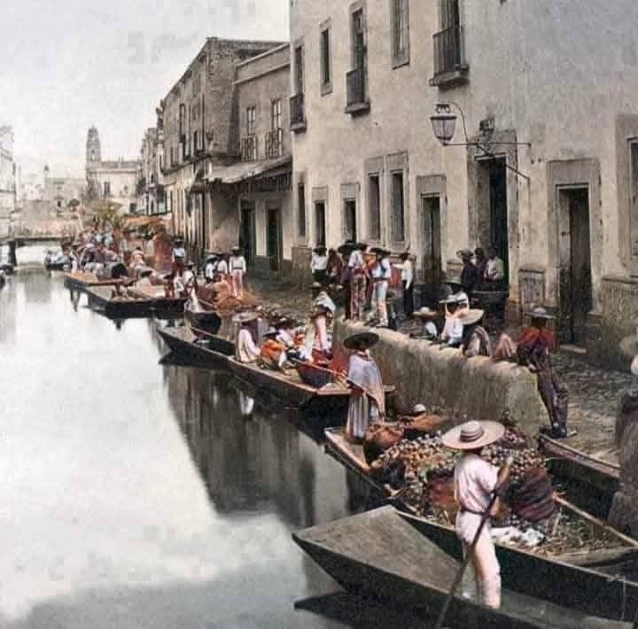
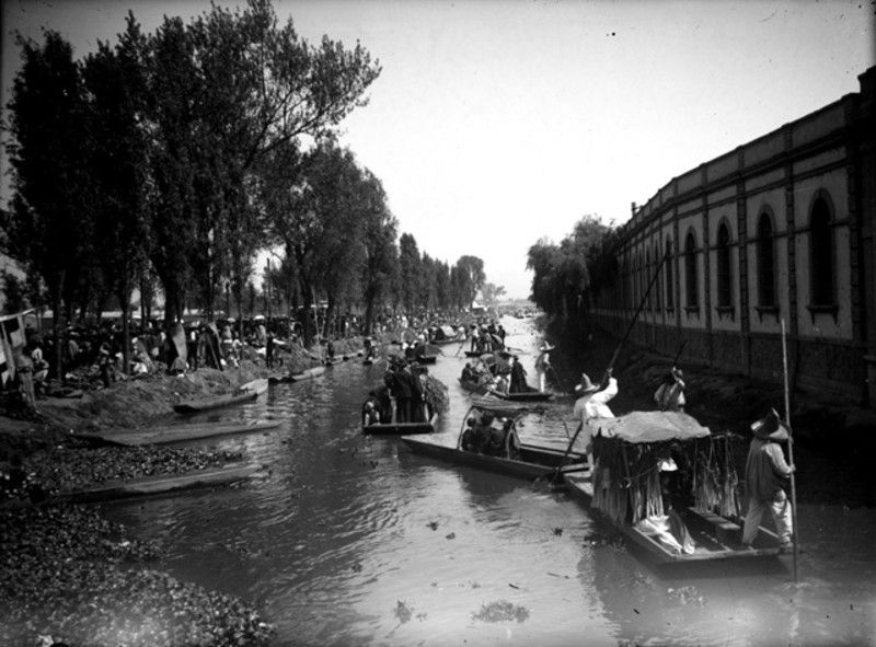
Many of these canals in the CDMX survived into fairly modern times at which point they were filled in to make the roads that now carry the goods previously shipped in by various water craft.
What became known as the Acequia Real, the Royal Canal, continued to connect Lake Xochimilco with the centre of the city. After Independence, it became known officially as the National Canal, but commonly as La Viga, “The Beam”.
The Viga (former Royal) Canal in 1850. It is superimposed on a map of Mexico City of 1970. Heavy red line up the centre is modern outer-ring expressway. Thin red line up left side is Calzada de Tlalpan, the former Mexica cuepotli, causeway.
la Calzada de la Viga
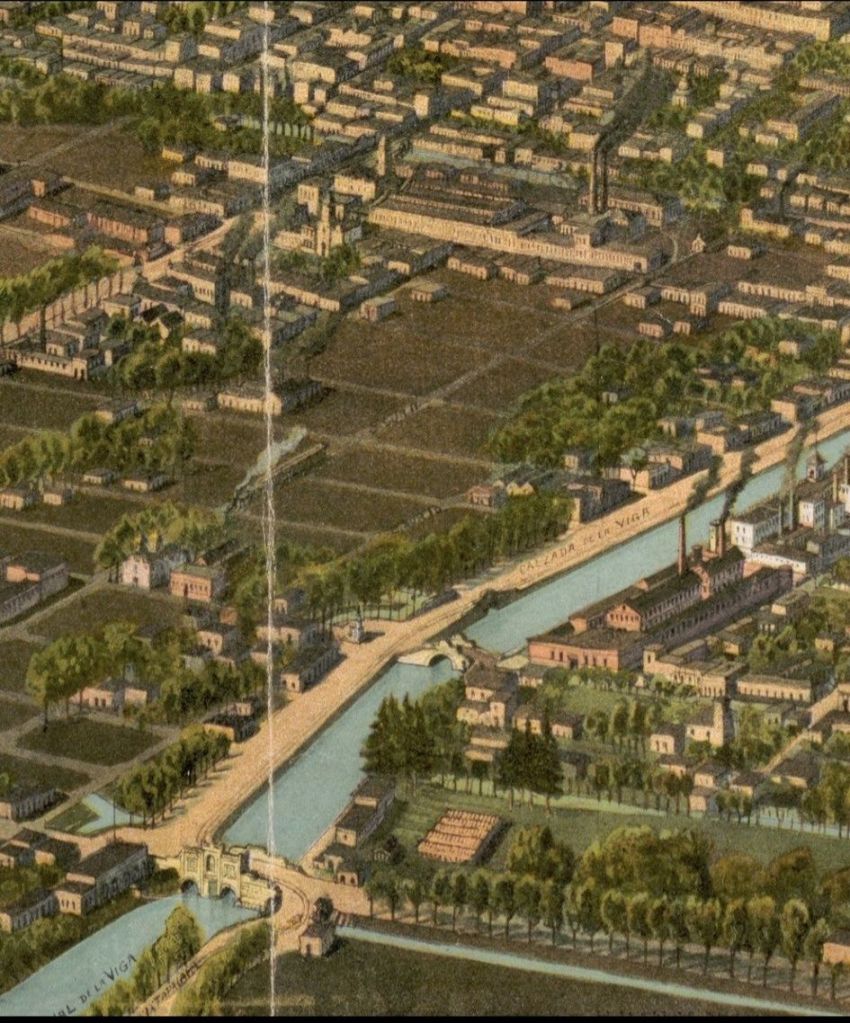
Postcard of la Calzada de la Viga Mexico City 1906
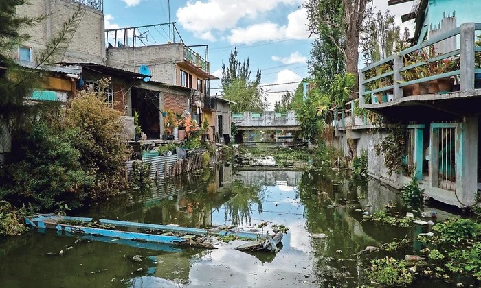
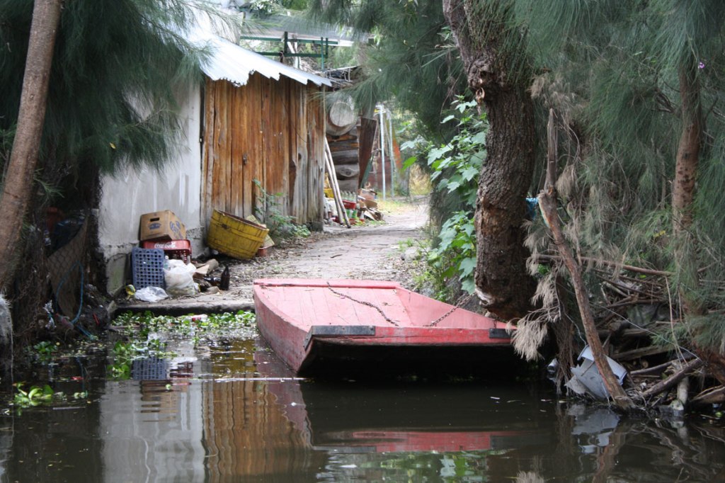
The chinampas of Xochimilco in an urban context
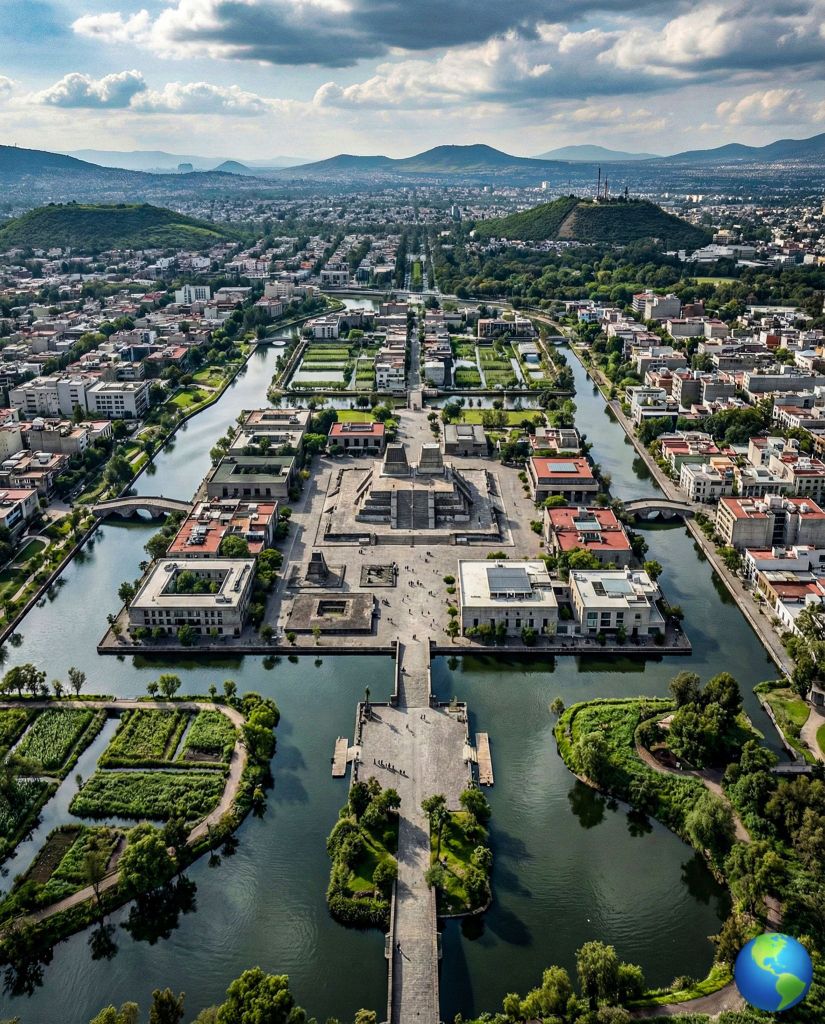
Artists impression of Tenochtitlan as it might appear today (if things had gone another way)

References
- Aguilar-Moreno, Manuel (October 3, 2007). Handbook to Life in the Aztec World. Oxford University Press
- Alcock, Susan E.; D’Altroy, Terence N.; Morrison, Kathleen D.; Sinopoli, Carla M. (June 2009). Empires: Perspectives from Archaeology and History. Cambridge University Press. ISBN 9780521112345.
- Alexandra Torres-Alves, Gina & Morales-Napoles, Oswaldo; (2019) Reliability Analysis of Flood Defenses: The Case of the Nezahualcoyotl Dike in the Aztec City of Tenochtitlan. Reliability Engineering and System Safety (2020), doi: https://doi.org/10.1016/j.ress.2020.107057
- BeBecerril, Jiménez (March 2007). “Potable water and sanitation in Tenochtitlan: Aztec culture”. Water Science and Technology. 7.rdan, Frances (2014). Aztec Archaeology and Ethnohistory. Cambridge University Press. pp. 78–79.
- Biar, Alexandra. (2021). Navigation paths and urbanism in the Basin of Mexico before the Conquest. Ancient Mesoamerica. 34. 1-20. 10.1017/S0956536121000328.
- Brule, Stephane & Enoch, Stefan & Guenneau, Sébastien. (2019). Role of nanophotonics in the birth of seismic megastructures. Nanophotonics. 8. 1591-1605. 10.1515/nanoph-2019-0106.
- Castaneda-Gonzalez, M. (2024). Water and the Aztec Empire. In: Corzo Perez, G.A., Hayde, L.G., Romero-López, R., Jiménez Palacios, A. (eds) Aqua Vitae. The Latin American Studies Book Series. Springer, Cham. https://doi.org/10.1007/978-3-031-57731-4_1
- Gálvez, Mariana (2021) Así se construyó (hace más de seis décadas) el primer rascacielos del mundo a prueba de terremotos. EL PAÍS, Edición Nacional : ARQUITECTURA . ICON Design 20 ABR 2021. https://elpais.com/icon-design/arquitectura/2021-04-20/asi-se-construyo-hace-mas-de-seis-decadas-el-primer-rascacielos-del-mundo-a-prueba-de-terremotos.html
- García-Govea, Coral & Rosales-Sierra, Victor. (2023). Forensic study of the Tula flooding in 2021.
- Herzog, Lawrence Arthur (2006). Return to the Center: Culture, Public Space, and City Building in a Global Era. University of Texas Press. pp. 119. ISBN 978-0-292-71262-1.
- Ingham, J. M. (1971). Time and Space in Ancient Mexico: The Symbolic Dimensions of Clanship. Man, 6(4), 615–629. https://doi.org/10.2307/2799186
- Karabatos I, Tsagkaris C, Kalachanis K. All roads lead to Rome: Aspects of public health in ancient Rome. Infez Med. 2021 Sep 10;29(3):488-491. doi: 10.53854/liim-2903-21. PMID: 35146355; PMCID: PMC8805493.
- Karttunen, Frances (1992) An Analytical Dictionary of Nahuatl (Norman: University of Oklahoma Press, 1992)
- León Portilla, Miguel, ed. (1992). The Broken Spears: the Aztec account of the Conquest of Mexico. Translated by Lysander Kemp. Boston: Beacon Press. p. 131. ISBN 9780807055007. OCLC 80748732.
- Levy, Buddy, Conquistador: Hernan Cortes, King Montezuma, and the Last Stands of the Aztecs, (New York: Bantam Books, 2008)
- Lockhart, James (2001) Nahuatl as Written: Lessons in Older Written Nahuatl, with Copious Examples and Texts (Stanford: Stanford University Press and UCLA Latin American Studies, 2001), 216.
- Lugo Viñas, R. (2025). The vicinity of the Plaza de Santo Domingo. Km Cero (195)
- McCarthy, K. (2019). An empire of water and stone : the Acuecuexco Aqueduct Relief. https://doi.org/10.26153/TSW/5497
- Mitchell, PD. Human parasites in the Roman World: health consequences of conquering an empire. Parasitology; 8 Jan 2016.
- Molina, Alonso de (1571) Vocabulario en lengua castellana y mexicana y mexicana y castellana, 1571, part 2, Nahuatl to Spanish, f. 27v. col. 2.
- Morehart, Christopher & Frederick, C.. (2014). The chronology and collapse of pre-Aztec raised field (chinampa) agriculture in the northern Basin of Mexico. Antiquity. 88. 531-548. 10.1017/S0003598X00101164.
- Morehart, C. T. (2016). CHINAMPA AGRICULTURE, SURPLUS PRODUCTION, AND POLITICAL CHANGE AT XALTOCAN, MEXICO. Ancient Mesoamerica, 27(1), 183–196. https://www.jstor.org/stable/26301996
- Morgado, Rossend Rovira; SAN PABLO TEOPAN: PERVIVENCIA Y METAMORFOSIS VIRREINAL DE UNA PARCIALIDAD INDÍGENA DE LA CIUDAD DE MÉXICO “San Pablo Teopan: Survival and Metamorphosis of an Indigenous Quarter of Mexico City During the Viceroy Period”
- Mundy, Barbara. “‘Place-Names in Mexico-Tenochtitlan.”,” n.d. doi:10.1215/00141801-2414190.
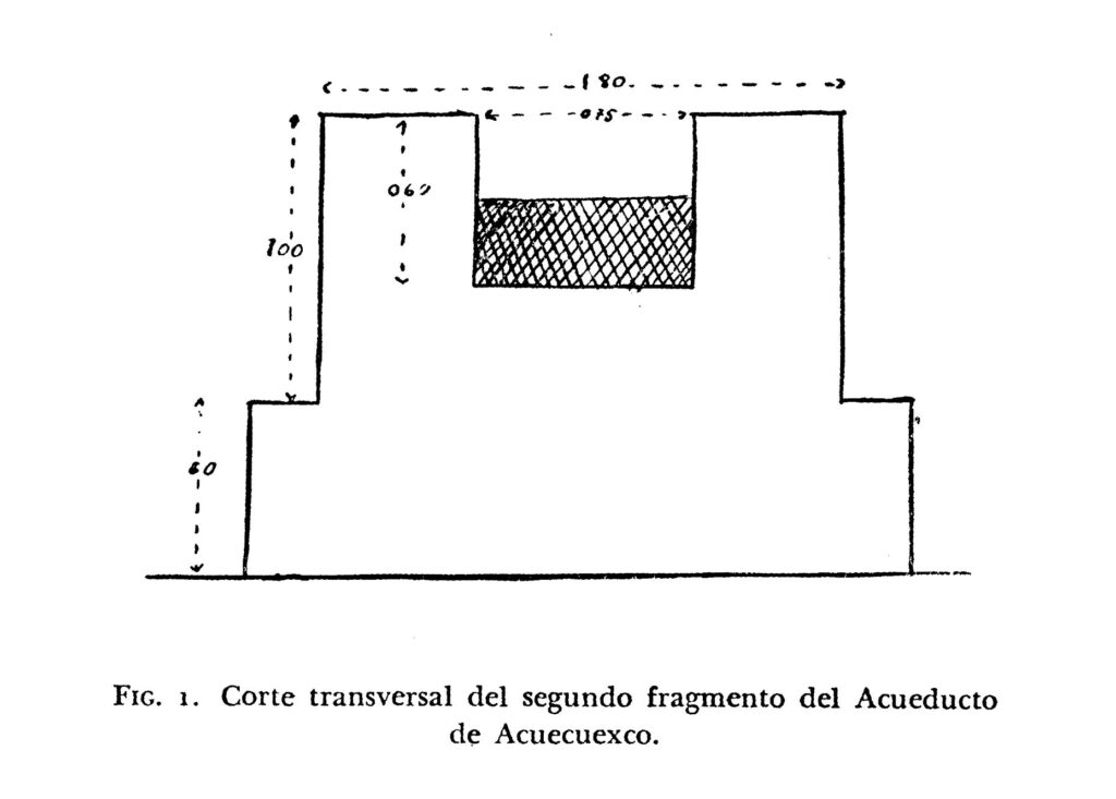
- Ramos, César Lizardi. (1954). El manantial y el acueducto de Acuecuexco. Historia Mexicana, 4(2), 218–234. http://www.jstor.org/stable/25134373
- Roca, Zoran (2011). Landscapes, Identities, and Development. Ashgate Publishing, Ltd.
- Sanders, William T., Jeffrey R. Parsons, and Robert S. Santley. 1979. The Basin of Mexico: Ecological Processes in the Evolution of a Civilization. New York: Academic Press
- Senturk, F. (1994). Hydraulics of dams and reservoirs. Water Resources Publications.
- Smith, Michael E. (2017)”Aztec Urbanism: Cities and Towns.” The Oxford Handbook of the Aztecs. Eds. Nichols, Deborah L. and Enrique Rodriguez-Alegria. Oxford: Oxford University Press
- Torres-Alves, Gina Alexandra & Morales-Nápoles, Oswaldo, 2020. “Reliability analysis of flood defenses: The case of the Nezahualcoyotl dike in the aztec city of Tenochtitlan,” Reliability Engineering and System Safety, Elsevier, vol. 203(C).
- Trowbridge, Edward D. (1919). Mexico To-day and To-morrow. Macmillan.
- Williams, Eduardo. (2023). AZTEC CERAMICS.
Websites
- Atl glyph : Visual Lexicon of Aztec Hieroglyphs : https://aztecglyphs.wired-humanities.org/content/atl-mdz24v
- Chinamitl : https://nahuatl.wired-humanities.org/content/chinamitl
- cozcatl. : https://nahuatl.wired-humanities.org/content/cozcatl
- Ehecacozcatl : Mesoweb : https://www.mesoweb.com/features/jpl/145.html
- Mexico City Ambles : La Viga Canal: Pathway From A Land of Lakes to One of Roadways : https://mexicocityperambulations.blogspot.com/p/la-viga-canal-from-lakes-to-canals-in.html
- SACMEX, El Gran Reto del Agua en la Ciudad de México. Pasado, presente y prospectivas de solución para una de las ciudades mas complejas del mundo, Ciudad de México, 2012. Sistemas de Agua de la Ciudad de México. https://d1wqtxts1xzle7.cloudfront.net/67706873/Una_aproximacion_a_la_Gobernanza_del_agu-libre.pdf?1624341157=&response-content-disposition=inline%3B+filename%3DUna_aproximacion_a_la_Gobernanza_del_agu.pdf&Expires=1773364171&Signature=VBILSp~zoiqY07ys-Qj-1zDsBpQG~Ptsl8hX2ffNOKL6AycnZfjFoYPCkglXlerCeuzka4Cnx8T5HK2I9QvpD8Gnxd26uodG6WZ2Z3AodE~p5DoHUrZwXN~jne2OzSehswbK2c3mYThMt2tzK9XfsWaWLp4uv~MZ3HSXIisvyieS1N1VcXgNkDPkRpgyusIAGCMJCGyJM3FwGqfCfKHJeslzLb1~EztYQRbIHwvbZSak1EPFAsfHtRYs5PxThPm3Q8kA46317t2ZDQ3uZM1jffl1nZ
UTeLWTOdoR~vcVmq4Kb97uD5XDZcppwPK6jQ5ek-mXDbXCkTx9EaV~Ew__&Key-Pair-Id=APKAJLOHF5GGSLRBV4ZA#page=72 - -tepec.: Online Nahuatl Dictionary : https://nahuatl.wired-humanities.org/content/tepec
- tepetl. : Online Nahuatl Dictionary : https://nahuatl.wired-humanities.org/content/tepetl
Images
- Alvarado’s leap (image) : https://artinmotioninternational.com/production/serials/gods-of-war/gods-of-war-contents/gods-of-war-pedro-de-alvarado/
- Apantle (Malinalco) Image via Apantles de Malinalco on Facebook : https://www.facebook.com/apantlesmalinalco/photos/repartidor-de-agua-en-el-pueblo-de-san-andr%C3%A9s-nicol%C3%A1s-bravo-%C3%BAltimo-tramo-del-apa/125108928913868/
- Apantle (Xochimilco) Mejoramiento de la calidad del agua a través del mantenimiento de apantles en la zona chinampera de Xochimilco : https://www.gob.mx/agricultura/cdmx/articulos/mejoramiento-de-la-calidad-del-agua-a-traves-del-mantenimiento-de-apantles-en-la-zona-chinampera-de-xochimilco?idiom=es
- Aztec Carved Shell Ornament of Ehecatl : https://galeriacontici.net/listings/aztec-carved-shell-ornament-of-ehecatl/
- Castillo de Teayo : Castillo de Teayo, el monumento a la pluralidad ancestral de Veracruz (JAN 2021) : https://mxc.com.mx/2021/01/15/castillo-de-teayo-el-monumento-a-la-pluralidad-ancestral-de-veracruz/
- Filsinger, Tomás J. (1985) (1992) (2012) (2018) (2021) ongoing. Maps of Tenochtitlan
- Kole, Thomas (2023) (2025) Tenochtitlan : CC BY 4.0 (Creative Commons Attribution 4.0 International). https://tenochtitlan.thomaskole.nl/
- Los Distintos Barrios de Tenochtitlan y Tlatelolco. (MAR 03 2026) Maravillas del México Antiguo y América / ADV Estudion : https://www.facebook.com/photo/?fbid=1349757937182593&set=a.431362412355488
- Modern chinampas : https://www.preventionweb.net/news/mexicos-floating-gardens-are-ancient-wonder-drought-mitigation
- Moyotlan : http://www.mexicomaxico.org/Tenoch/TenochBarrios1519Reformado.htm#inicio
- Semo Garcia, Andrés (SemoDron) Images Mexico City/Tenochtitlan : CC BY 4.0 (Creative Commons Attribution 4.0 International).
